
Faire un don
Équipez-vous pour votre prochaine aventure :
En tant que Partenaire Amazon, ce site perçoit une commission sur les achats éligibles sans surcoût pour vous.
Carte topographique Mount Hutt
Cliquez sur la carte pour afficher l’altitude.
Faire un don
Équipez-vous pour votre prochaine aventure :
En tant que Partenaire Amazon, ce site perçoit une commission sur les achats éligibles sans surcoût pour vous.
À propos de cette carte
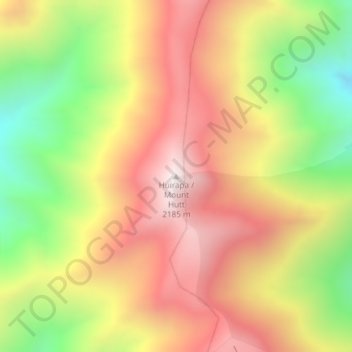
Nom : Carte topographique Mount Hutt, altitude, relief.
Lieu : Mount Hutt, Ashburton District, Canterbury, New Zealand (-43.47154 171.52601 -43.47144 171.52611)
Altitude moyenne : 1 732 m
Altitude minimum : 1 198 m
Altitude maximum : 2 185 m
Faire un don
Équipez-vous pour votre prochaine aventure :
En tant que Partenaire Amazon, ce site perçoit une commission sur les achats éligibles sans surcoût pour vous.
Autres cartes topographiques
Cliquez sur une carte pour visualiser sa topographie, son altitude et son relief.
Methven
New Zealand > Canterbury > Ashburton District
Methven is a small town in the Canterbury region of the South Island of New Zealand. It is located near the western edge of the Canterbury Plains, 34 km (21 mi) north of Ashburton and 95 km (59 mi) west of Christchurch, and at an elevation of 320 m (1,050 ft). The town is a service centre for agriculture in…
Altitude moyenne : 321 m
Faire un don
Équipez-vous pour votre prochaine aventure :
En tant que Partenaire Amazon, ce site perçoit une commission sur les achats éligibles sans surcoût pour vous.