
Carte topographique City of Johannesburg Metropolitan Municipality
Carte interactive
Cliquez sur la carte pour afficher l’altitude.
À propos de cette carte
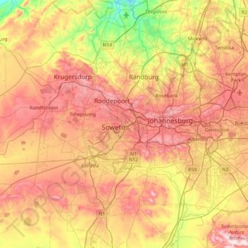
Nom : Carte topographique City of Johannesburg Metropolitan Municipality, altitude, relief.
Lieu : City of Johannesburg Metropolitan Municipality, Gauteng, RSA (-26.52629 27.71427 -25.90283 28.21446)
Altitude moyenne : 1 582 m
Altitude minimum : 1 275 m
Altitude maximum : 1 909 m
Autres cartes topographiques
Cliquez sur une carte pour visualiser sa topographie, son altitude et son relief.
Ekurhuleni Ward 75
Ekurhuleni Ward 75, Springs, City of Ekurhuleni Metropolitan Municipality, Gauteng, RSA
Altitude moyenne : 1 605 m
Johannesburg Ward 97
RSA > Gauteng > Roodepoort
Johannesburg Ward 97, Roodepoort, City of Johannesburg Metropolitan Municipality, Gauteng, 2040, RSA
Altitude moyenne : 1 582 m
Ekurhuleni Ward 73
Ekurhuleni Ward 73, Benoni, City of Ekurhuleni Metropolitan Municipality, Gauteng, 1501, RSA
Altitude moyenne : 1 631 m
Johannesburg Ward 120
Johannesburg Ward 120, Soweto, City of Johannesburg Metropolitan Municipality, Gauteng, 1829, RSA
Altitude moyenne : 1 639 m
Tshwane Ward 6
Tshwane Ward 6, Mamelodi, City of Tshwane Metropolitan Municipality, Gauteng, RSA
Altitude moyenne : 1 314 m
Roodeplaat Dam
Roodeplaat Dam, Dwars Road, Tshwane Ward 99, Pretoria, City of Tshwane Metropolitan Municipality, Gauteng, 0035, RSA
Altitude moyenne : 1 240 m