
Faire un don
Équipez-vous pour votre prochaine aventure :
En tant que Partenaire Amazon, ce site perçoit une commission sur les achats éligibles sans surcoût pour vous.
Carte topographique Lake Massapoag
Cliquez sur la carte pour afficher l’altitude.
Faire un don
Équipez-vous pour votre prochaine aventure :
En tant que Partenaire Amazon, ce site perçoit une commission sur les achats éligibles sans surcoût pour vous.
Lake Massapoag
Because of the lake and the fact that Sharon is at a slightly higher elevation than the surrounding towns, and because it is located on the main rail line going south from Boston, the shores of the lake developed into a minor summer resort with several large hotels, summer camps and cottage colonies. Temple Adath Sharon was built as a summer synagogue, and the houses around it, now occupied year-round, were once summer cottages.
Faire un don
Équipez-vous pour votre prochaine aventure :
En tant que Partenaire Amazon, ce site perçoit une commission sur les achats éligibles sans surcoût pour vous.
À propos de cette carte
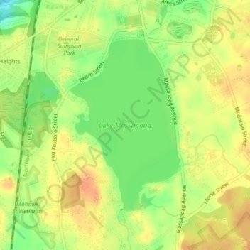
Nom : Carte topographique Lake Massapoag, altitude, relief.
Altitude moyenne : 84 m
Altitude minimum : 61 m
Altitude maximum : 98 m
Faire un don
Équipez-vous pour votre prochaine aventure :
En tant que Partenaire Amazon, ce site perçoit une commission sur les achats éligibles sans surcoût pour vous.
Autres cartes topographiques
Cliquez sur une carte pour visualiser sa topographie, son altitude et son relief.