
Faire un don
Équipez-vous pour votre prochaine aventure :
En tant que Partenaire Amazon, ce site perçoit une commission sur les achats éligibles sans surcoût pour vous.
Carte topographique Sullurpeta
Cliquez sur la carte pour afficher l’altitude.
Faire un don
Équipez-vous pour votre prochaine aventure :
En tant que Partenaire Amazon, ce site perçoit une commission sur les achats éligibles sans surcoût pour vous.
Sullurpeta
Sullurupeta is located about 77 km east of Tirupati, 90 km south of Nellore and about 83 km north of Chennai, Tamilnadu. It is 16 km west of the world-famous ISRO island Sriharikota, where the Indian rockets are launched. The Pulicat lake separates Sullurpeta and Sriharikota. It has an average elevation of 11 meters (36 feet).
Faire un don
Équipez-vous pour votre prochaine aventure :
En tant que Partenaire Amazon, ce site perçoit une commission sur les achats éligibles sans surcoût pour vous.
À propos de cette carte
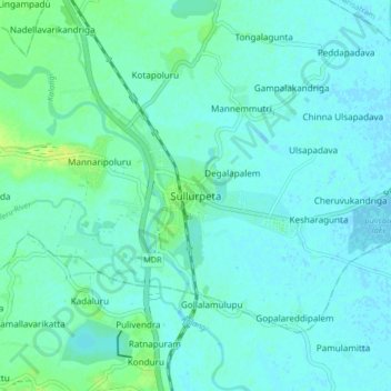
Nom : Carte topographique Sullurpeta, altitude, relief.
Lieu : Sullurpeta, Tirupati District, Andhra Pradesh, 524121, India (13.66129 79.98070 13.74129 80.06070)
Altitude moyenne : 4 m
Altitude minimum : -2 m
Altitude maximum : 15 m
Faire un don
Équipez-vous pour votre prochaine aventure :
En tant que Partenaire Amazon, ce site perçoit une commission sur les achats éligibles sans surcoût pour vous.