
Carte topographique Rabigh
Carte interactive
Cliquez sur la carte pour afficher l’altitude.
À propos de cette carte
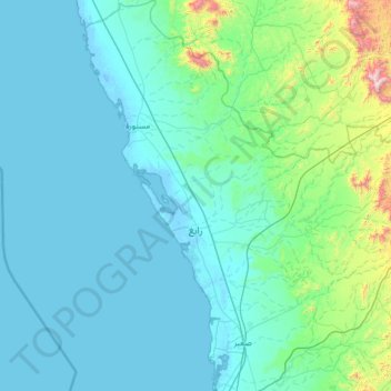
Nom : Carte topographique Rabigh, altitude, relief.
Lieu : Rabigh, Makkah Region, 23955, Saudi Arabia (22.30247 38.65977 23.49728 39.88517)
Altitude moyenne : 145 m
Altitude minimum : -7 m
Altitude maximum : 1 730 m
Rabigh (Arabic: رَابِغ, romanized: Rābigh) is a city and governorate in the Province of Makkah of the Kingdom of Saudi Arabia, situated on the coast of the Red Sea, around 208 km (129 mi) northwest of Mecca in the historic Hejazi region. The city had an estimated population of 180,352 in 2014 and is situated at an elevation of 13 m (43 ft) above sea level, close to the border with the Madinah Province. The city dates back to the era before the advent of Islam in the 7th century C.E., and up to the 17th century, was known as Al-Juhfah, or Al-Johfah (Arabic: ٱلْجُحْفَة, romanized: Al-Juḥfah).
Autres cartes topographiques
Cliquez sur une carte pour visualiser sa topographie, son altitude et son relief.
Jeddah
Jeddah, Governorate of Jidda, Makkah Region, 23434, Saudi Arabia
Altitude moyenne : 35 m
Governorate of Jidda
Governorate of Jidda, Makkah Region, Saudi Arabia
Altitude moyenne : 130 m
Makkah Al Mukarramah
Makkah Al Mukarramah, Makkah Region, Saudi Arabia
Altitude moyenne : 479 m
الباب
الباب, Khulays, Makkah Region, Saudi Arabia
Altitude moyenne : 886 m