
Faire un don
Équipez-vous pour votre prochaine aventure :
En tant que Partenaire Amazon, ce site perçoit une commission sur les achats éligibles sans surcoût pour vous.
Carte topographique Cloudcroft
Cliquez sur la carte pour afficher l’altitude.
Faire un don
Équipez-vous pour votre prochaine aventure :
En tant que Partenaire Amazon, ce site perçoit une commission sur les achats éligibles sans surcoût pour vous.
Cloudcroft
Cloudcroft is a village in Otero County, New Mexico, United States, and is located within the Lincoln National Forest. The population was 674 at the 2010 census. Despite being located in an otherwise arid region, its high elevation (8,676 feet (2,644 m); one of the highest in the U.S.) allows for a mild summer that makes it a popular tourist attraction in west Texas and southern New Mexico. It was named by Fodor's in 2002 as the Number 3 "Most Overlooked and Underrated Destination Spot." Tourism remains the primary economic driver of the village.
Faire un don
Équipez-vous pour votre prochaine aventure :
En tant que Partenaire Amazon, ce site perçoit une commission sur les achats éligibles sans surcoût pour vous.
À propos de cette carte
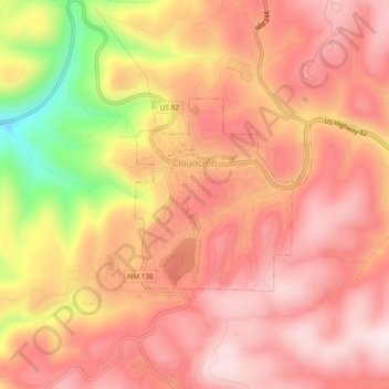
Nom : Carte topographique Cloudcroft, altitude, relief.
Lieu : Cloudcroft, Otero County, New Mexico, United States (32.94456 -105.75004 32.96421 -105.70277)
Altitude moyenne : 2 643 m
Altitude minimum : 2 352 m
Altitude maximum : 2 776 m
Faire un don
Équipez-vous pour votre prochaine aventure :
En tant que Partenaire Amazon, ce site perçoit une commission sur les achats éligibles sans surcoût pour vous.
Autres cartes topographiques
Cliquez sur une carte pour visualiser sa topographie, son altitude et son relief.
High Rolls
United States > New Mexico > Otero County
The first official use of the High Rolls name was in 1901, when the post office was moved from Fresnal (Wooten) to High Rolls. The name, which was sometimes spelled as one word, Highrolls, supposedly came from the shape and elevation of the area as compared to the sharper peaks higher up.
Altitude moyenne : 2 036 m
Sunspot
United States > New Mexico > Otero County
Sunspot is an unincorporated community in the Sacramento Mountains in the Lincoln National Forest in Otero County, New Mexico, United States, about 18 miles (29 km) south of Cloudcroft. Its elevation is 9,186 feet (2,800 m). The Sunspot Solar Observatory and Apache Point Observatory are located in Sunspot in…
Altitude moyenne : 2 626 m
Faire un don
Équipez-vous pour votre prochaine aventure :
En tant que Partenaire Amazon, ce site perçoit une commission sur les achats éligibles sans surcoût pour vous.
Chihuahuan Desert
United States > New Mexico > Otero County
There are several larger mountain ranges in the Chihuahan Desert, including the Sierra Madre, the Sierra del Carmen, the Organ Mountains, the Franklin Mountains, the Sacramento Mountains, the Chisos Mountains, the Guadalupe Mountains, and the Davis Mountains. These create "sky islands" of cooler, wetter,…
Altitude moyenne : 1 221 m
High Rolls
United States > New Mexico > Otero County
The first official use of the High Rolls name was in 1901, when the post office was moved from Fresnal (Wooten) to High Rolls. The name, which was sometimes spelled as one word, Highrolls, supposedly came from the shape and elevation of the area as compared to the sharper peaks higher up.
Altitude moyenne : 2 036 m
Faire un don
Équipez-vous pour votre prochaine aventure :
En tant que Partenaire Amazon, ce site perçoit une commission sur les achats éligibles sans surcoût pour vous.
Sunspot
United States > New Mexico > Otero County
The origins of Sunspot as a Solar Observatory date back to the sudden increased interest of solar physics to the US military during the Second World War. In 1940, the High Altitude Observatory (HAO) was established in 1940 in Climax, Colorado, by Walter Orr Roberts and Donald Menzel. It was associated with…
Altitude moyenne : 2 626 m
Cloudcroft
United States > New Mexico > Otero County > Cloudcroft
Cloudcroft is a village in Otero County, New Mexico, United States, and is located within the Lincoln National Forest. The population was 674 at the 2010 census. Despite being located in an otherwise arid region, its high elevation (8,676 feet (2,644 m); one of the highest in the U.S.) allows for a mild summer…
Altitude moyenne : 2 636 m