
Carte topographique Graffham
Cliquez sur la carte pour afficher l’altitude.
À propos de cette carte
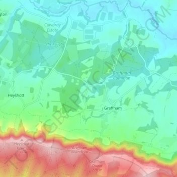
Nom : Carte topographique Graffham, altitude, relief.
Lieu : Graffham, Chichester, West Sussex, England, United Kingdom (50.93078 -0.70620 50.98420 -0.66116)
Altitude moyenne : 73 m
Altitude minimum : 9 m
Altitude maximum : 237 m
Autres cartes topographiques
Cliquez sur une carte pour visualiser sa topographie, son altitude et son relief.
Donnington Park
United Kingdom > England > West Sussex > Chichester > Donnington
Altitude moyenne : 8 m
Horncroft Common Plantation
United Kingdom > England > West Sussex > Chichester
Altitude moyenne : 22 m
Blackdown
United Kingdom > England > West Sussex > Chichester
Blackdown, or Black Down, summit elevation 279.7 metres (918 ft) AMSL, is the highest point in both the historic county of Sussex and the South Downs National Park. It is one of the highest points in the south east of England, exceeded by Walbury Hill, Leith Hill and Pilot Hill. Blackdown is protected as part…
Altitude moyenne : 165 m