
Carte topographique High Roding
Cliquez sur la carte pour afficher l’altitude.
À propos de cette carte
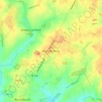
Nom : Carte topographique High Roding, altitude, relief.
Lieu : High Roding, Uttlesford, Essex, England, CM6 1YH, United Kingdom (51.81016 0.30609 51.85016 0.34609)
Altitude moyenne : 79 m
Altitude minimum : 61 m
Altitude maximum : 93 m
Autres cartes topographiques
Cliquez sur une carte pour visualiser sa topographie, son altitude et son relief.
Coles Green
United Kingdom > England > Essex > Uttlesford > Berden > Little London
Altitude moyenne : 100 m
Stansted Mountfitchet
United Kingdom > England > Essex > Uttlesford > Stansted Mountfitchet
Altitude moyenne : 89 m
Little Easton
United Kingdom > England > Essex > Uttlesford > Little Easton
Living in the parish were Lord and Lady Brooke, the later Earl and Countess of Warwick, at Easton Lodge, who were also resident at Berwick House in the Stable Yard of St James's Palace, London, and in 1902, after elevation to title, Warwick Castle. Parish occupations in 1882 included three farmers, one of whom…
Altitude moyenne : 88 m
Great Hallingbury
United Kingdom > England > Essex > Uttlesford > Great Hallingbury
Altitude moyenne : 81 m
Hatfield Forest
United Kingdom > England > Essex > Uttlesford > Takeley Street
Altitude moyenne : 90 m