Carte topographique Vicdessos
Carte interactive
Cliquez sur la carte pour afficher l’altitude.
À propos de cette carte
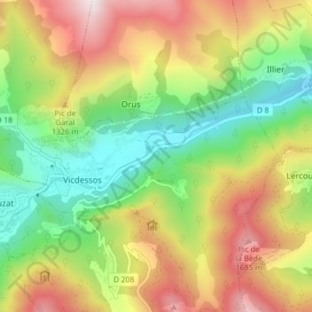
Autres cartes topographiques
Cliquez sur une carte pour visualiser sa topographie, son altitude et son relief.
Suc
France > Occitanie > Ariège > Val-de-Sos
Suc, Suc-et-Sentenac, Val-de-Sos, Foix, Ariège, Occitanie, France métropolitaine, 09220, France
Altitude moyenne : 1 149 m
Sentenac
France > Occitanie > Ariège > Val-de-Sos
Sentenac, Suc-et-Sentenac, Val-de-Sos, Foix, Ariège, Occitanie, France métropolitaine, 09220, France
Altitude moyenne : 1 100 m
Arconac
France > Occitanie > Ariège > Val-de-Sos
Arconac, Vicdessos, Val-de-Sos, Foix, Ariège, Occitanie, France métropolitaine, 09220, France
Altitude moyenne : 1 095 m
Sem
France > Occitanie > Ariège > Val-de-Sos
Sem, Val-de-Sos, Foix, Ariège, Occitanie, France métropolitaine, 09220, France
Altitude moyenne : 1 346 m
Goulier
France > Occitanie > Ariège > Val-de-Sos
Goulier, Val-de-Sos, Foix, Ariège, Occitanie, France métropolitaine, 09220, France
Altitude moyenne : 1 484 m
Cabre
France > Occitanie > Ariège > Val-de-Sos
Cabre, Vicdessos, Val-de-Sos, Foix, Ariège, Occitanie, France métropolitaine, 09220, France
Altitude moyenne : 1 088 m
Suc-et-Sentenac
France > Occitanie > Ariège > Val-de-Sos
Suc-et-Sentenac, Val-de-Sos, Foix, Ariège, Occitanie, France métropolitaine, 09220, France
Altitude moyenne : 1 537 m
Retrouvance Terre d'avenir
France > Occitanie > Ariège > Val-de-Sos
Retrouvance Terre d'avenir, D 18, Suc-et-Sentenac, Val-de-Sos, Foix, Ariège, Occitanie, France métropolitaine, France
Altitude moyenne : 1 585 m
Étang d'Arbu
France > Occitanie > Ariège > Val-de-Sos
Étang d'Arbu, Suc-et-Sentenac, Val-de-Sos, Foix, Ariège, Occitanie, France métropolitaine, 09220, France
Altitude moyenne : 1 794 m