
Carte topographique Johnson County
Carte interactive
Cliquez sur la carte pour afficher l’altitude.
À propos de cette carte
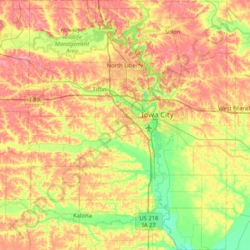
Nom : Carte topographique Johnson County, altitude, relief.
Lieu : Johnson County, Iowa, United States (41.42221 -91.83418 41.86204 -91.36589)
Altitude moyenne : 226 m
Altitude minimum : 181 m
Altitude maximum : 278 m
Autres cartes topographiques
Cliquez sur une carte pour visualiser sa topographie, son altitude et son relief.
Hills
United States > Iowa > Johnson County
Hills, Johnson County, Iowa, 52235, United States
Altitude moyenne : 196 m
Hills
United States > Iowa > Johnson County > Hills > Hills
Hills, Johnson County, Iowa, 52235, United States
Altitude moyenne : 196 m
Iowa City
United States > Iowa > Johnson County > Iowa City
Iowa City, Johnson County, Iowa, 52240-5544, United States
Altitude moyenne : 225 m
Penn Township
United States > Iowa > Johnson County
Penn Township, Johnson County, Iowa, United States
Altitude moyenne : 232 m
Iowa City
United States > Iowa > Johnson County
Iowa City, Johnson County, Iowa, United States
Altitude moyenne : 216 m