
Carte topographique Floridablanca
Carte interactive
Cliquez sur la carte pour afficher l’altitude.
À propos de cette carte
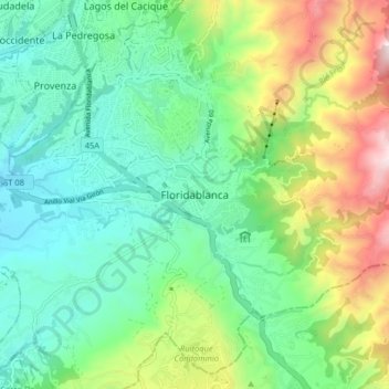
Nom : Carte topographique Floridablanca, altitude, relief.
Lieu : Floridablanca, Metropolitana, Santander, 681004, Colombia (7.02254 -73.12582 7.10254 -73.04582)
Altitude moyenne : 1 091 m
Altitude minimum : 753 m
Altitude maximum : 1 879 m
Floridablanca is situated at an altitude of about 925 metres (3,035 ft) in the Eastern Ranges of the Colombian Andes, though locally the topography varies greatly. To the east of the city the higher mountains of the Andes rise above the city, thrusted upwards by the north–south-trending Bucaramanga-Santa Marta Fault, one of the major megaregional faults of Colombia. The area is dominated by the Bucaramanga Nest, the second-most seismically active region in the world. Because of the relatively low altitude, the city enjoys a very favorable climate all year round. Floridablanca's climate is classified as tropical. When compared with winter, the summers have much more rainfall. The climate is classified as Aw (tropical savanna climate) by the Köppen-Geiger system. The average annual temperature is 23.6 °C (74.5 °F) in Floridablanca. The rainfall averages 1,055 millimetres (41.5 in) per year.