
Faire un don
Équipez-vous pour votre prochaine aventure :
En tant que Partenaire Amazon, ce site perçoit une commission sur les achats éligibles sans surcoût pour vous.
Carte topographique Brund Fell (summit)
Cliquez sur la carte pour afficher l’altitude.
Faire un don
Équipez-vous pour votre prochaine aventure :
En tant que Partenaire Amazon, ce site perçoit une commission sur les achats éligibles sans surcoût pour vous.
Brund Fell (summit)
The fell has a summit plateau which consist of many heather-covered hummocks, drystone walls and clumps of trees. Well-known Lake District writer Alfred Wainwright credits Grange Fell as a single fell with three main summits, namely Brund Fell, King's How and Ether Knott. The lesser known Ether Knott is now identified as the highest point at a height of 419 metres (1,375 feet) and is less frequently visited by walkers. Brund Fell is at 415 metres (1,362 feet) while King's How is the best viewpoint and has an altitude of 392 metres (1,286 feet). On the other hand, another Lakes walking expert Bill Birkett lists Brund Fell and King's How as separate fells in his “Complete Lakeland Fells” volume, while Mark Richards includes all three.
Faire un don
Équipez-vous pour votre prochaine aventure :
En tant que Partenaire Amazon, ce site perçoit une commission sur les achats éligibles sans surcoût pour vous.
À propos de cette carte
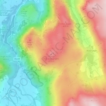
Nom : Carte topographique Brund Fell (summit), altitude, relief.
Altitude moyenne : 252 m
Altitude minimum : 78 m
Altitude maximum : 455 m
Faire un don
Équipez-vous pour votre prochaine aventure :
En tant que Partenaire Amazon, ce site perçoit une commission sur les achats éligibles sans surcoût pour vous.
Autres cartes topographiques
Cliquez sur une carte pour visualiser sa topographie, son altitude et son relief.