
Carte topographique Red Tarns
Carte interactive
Cliquez sur la carte pour afficher l’altitude.
À propos de cette carte
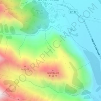
Nom : Carte topographique Red Tarns, altitude, relief.
Altitude moyenne : 997 m
Altitude minimum : 676 m
Altitude maximum : 1 637 m
Autres cartes topographiques
Cliquez sur une carte pour visualiser sa topographie, son altitude et son relief.
Mount Cook Village
New Zealand > Canterbury > Mount Cook Village
Mount Cook Village, Mackenzie District, Canterbury, 7946, New Zealand
Altitude moyenne : 984 m
Eugenie Glacier
New Zealand > Canterbury > Mount Cook Village
Eugenie Glacier, Hooker Valley Track, Mount Cook Village, Mackenzie District, Canterbury, 7946, New Zealand
Altitude moyenne : 1 827 m
Mueller Glacier
New Zealand > Canterbury > Mount Cook Village
Mueller Glacier, Mueller Hut Route, Mount Cook Village, Mackenzie District, Canterbury, 7946, New Zealand
Altitude moyenne : 1 616 m