
Carte topographique West Hartford
Carte interactive
Cliquez sur la carte pour afficher l’altitude.
À propos de cette carte
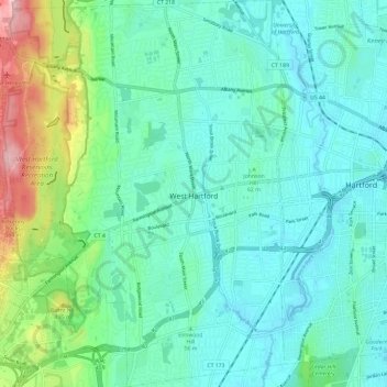
Nom : Carte topographique West Hartford, altitude, relief.
Altitude moyenne : 60 m
Altitude minimum : 9 m
Altitude maximum : 250 m
The west side of West Hartford is flanked by the Metacomet Ridge, a mountainous trap rock ridgeline that stretches from Long Island Sound to nearly the Vermont border. Notable features of the Metacomet Ridge in West Hartford include Talcott Mountain and a number of highland water reservoirs belonging to the Metropolitan District, which maintains watershed and recreation resources on the property. The 51-mile-long (82 km) Metacomet Trail traverses the ridge. The town's web site indicates that the highest point in town is 778 feet (237 m) above sea level on Talcott (Avon) Mountain. The altitude at Town Hall is 120 feet (37 m).
Autres cartes topographiques
Cliquez sur une carte pour visualiser sa topographie, son altitude et son relief.
Whites Hill
United States > Connecticut > Capitol Planning Region > Bolton
Whites Hill, Bolton, Capitol Planning Region, Connecticut, 06043, United States
Altitude moyenne : 205 m
Glastonbury
United States > Connecticut > Capitol Planning Region
Glastonbury, Capitol Planning Region, Connecticut, United States
Altitude moyenne : 67 m
South Windsor
United States > Connecticut > Capitol Planning Region
South Windsor, Capitol Planning Region, Connecticut, United States
Altitude moyenne : 42 m
Hartford County
United States > Connecticut > Capitol Planning Region
Hartford County, Capitol Planning Region, Connecticut, United States
Altitude moyenne : 122 m