
Carte topographique Taylorsville
Carte interactive
Cliquez sur la carte pour afficher l’altitude.
À propos de cette carte
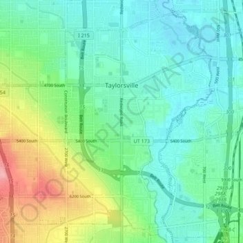
Nom : Carte topographique Taylorsville, altitude, relief.
Lieu : Taylorsville, Salt Lake County, Utah, United States (40.62985 -111.99155 40.68633 -111.90783)
Altitude moyenne : 1 325 m
Altitude minimum : 1 293 m
Altitude maximum : 1 410 m
The land on which Taylorsville is located is part of an interconnected alluvial plain that was formed by the wearing down of the Wasatch and Oquirrh Mountains to the east and west. Beneath the surface, Taylorsville sits on more than a kilometer of unconsolidated rock, sand, and clay. The inactive Taylorsville Fault has been traced down the center of the Salt Lake Valley. Lake Bonneville shaped the topography of the area and deposited lake bottom clay and sand. As Lake Bonneville dried up over the past 14,000 years, the salt from the breakdown of rock remains, making the soil alkaline. Like most desert soils, it has little organic material and is hard to work.
Autres cartes topographiques
Cliquez sur une carte pour visualiser sa topographie, son altitude et son relief.
Draper Commercial Parkway
United States > Utah > Salt Lake County > Draper
Draper Commercial Parkway, Draper, Salt Lake County, Utah, 84020, United States
Altitude moyenne : 1 355 m
Magna
United States > Utah > Salt Lake County
Magna, Salt Lake County, Utah, United States
Altitude moyenne : 1 341 m
Bellwood Acres
United States > Utah > Salt Lake County > Cottonwood Heights
Bellwood Acres, Cottonwood Heights, Salt Lake County, Utah, 84121, United States
Altitude moyenne : 1 398 m
Sprucewood
United States > Utah > Salt Lake County > Sandy
Sprucewood, Sandy, Salt Lake County, Utah, 84094, United States
Altitude moyenne : 1 418 m
West Valley City
United States > Utah > Salt Lake County
West Valley City, Salt Lake County, Utah, United States
Altitude moyenne : 1 351 m
Alta
United States > Utah > Salt Lake County
Alta, Salt Lake County, Utah, United States
Altitude moyenne : 2 912 m
Brighton
United States > Utah > Salt Lake County
Brighton, Salt Lake County, Utah, United States
Altitude moyenne : 2 852 m
West Jordan
United States > Utah > Salt Lake County
West Jordan, Salt Lake County, Utah, United States
Altitude moyenne : 1 372 m
Midvale
United States > Utah > Salt Lake County
Midvale, Salt Lake County, Utah, 84047, United States
Altitude moyenne : 1 331 m
Salt Lake City
United States > Utah > Salt Lake County
Salt Lake City, Salt Lake County, Utah, United States
Altitude moyenne : 1 592 m
Salt Lake City
United States > Utah > Salt Lake County > Salt Lake City
Salt Lake City, Salt Lake County, Utah, 84139, United States
Altitude moyenne : 1 625 m
Sandy
United States > Utah > Salt Lake County
Sandy, Salt Lake County, Utah, United States
Altitude moyenne : 1 376 m
Hillborough Heights
United States > Utah > Salt Lake County > Sandy > Hillborough Heights
Hillborough Heights, Sandy, Salt Lake County, Utah, 84093, United States
Altitude moyenne : 1 501 m
South Valence Drainage
United States > Utah > Salt Lake County > West Jordan
South Valence Drainage, West Jordan, Salt Lake County, Utah, United States
Altitude moyenne : 1 388 m
Millcreek
United States > Utah > Salt Lake County > Millcreek
Millcreek, Salt Lake County, Utah, 84106, United States
Altitude moyenne : 1 715 m
South Jordan
United States > Utah > Salt Lake County > South Jordan
South Jordan, Salt Lake County, Utah, United States
Altitude moyenne : 1 384 m
Snowbird
United States > Utah > Salt Lake County
Snowbird, Salt Lake County, Utah, 85092, United States
Altitude moyenne : 2 760 m
Draper
United States > Utah > Salt Lake County
Draper, Salt Lake County, Utah, 84020, United States
Altitude moyenne : 1 573 m