
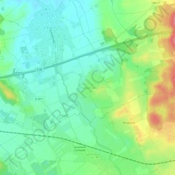
Carte topographique Schlegelsberg
Carte interactive
Cliquez sur la carte pour afficher l’altitude.
À propos de cette carte
Nom : Carte topographique Schlegelsberg, altitude, relief.
Altitude moyenne : 617 m
Altitude minimum : 589 m
Altitude maximum : 671 m
Autres cartes topographiques
Cliquez sur une carte pour visualiser sa topographie, son altitude et son relief.
Markt Wald
Germany > Bavaria > Landkreis Unterallgäu
Markt Wald, Landkreis Unterallgäu, Bavaria, 86865, Germany
Altitude moyenne : 603 m
Kettershausen
Germany > Bavaria > Landkreis Unterallgäu
Kettershausen, Babenhausen, Landkreis Unterallgäu, Bavaria, 86498, Germany
Altitude moyenne : 555 m