
Carte topographique Uludağ
Carte interactive
Cliquez sur la carte pour afficher l’altitude.
À propos de cette carte
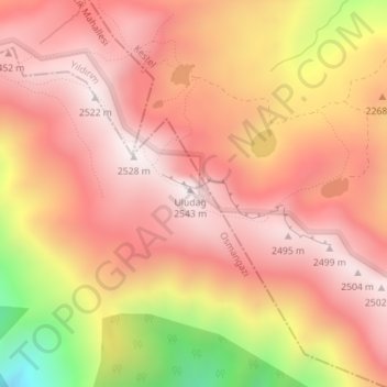
Nom : Carte topographique Uludağ, altitude, relief.
Lieu : Uludağ, Osmangazi, Bursa, Marmara Region, Turkey (40.07048 29.22196 40.07058 29.22206)
Altitude moyenne : 2 265 m
Altitude minimum : 1 698 m
Altitude maximum : 2 535 m
Uludağ (Turkish pronunciation: [ˈuɫudaː]), the ancient Mysian or Bithynian Olympus (Greek: Όλυμπος), is a mountain in Bursa Province, Turkey, with an elevation of 2,543 m (8,343 ft).
Autres cartes topographiques
Cliquez sur une carte pour visualiser sa topographie, son altitude et son relief.