
Carte topographique Stretton
Cliquez sur la carte pour afficher l’altitude.
À propos de cette carte
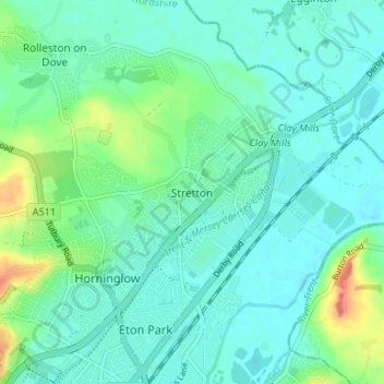
Nom : Carte topographique Stretton, altitude, relief.
Altitude moyenne : 55 m
Altitude minimum : 40 m
Altitude maximum : 105 m
Autres cartes topographiques
Cliquez sur une carte pour visualiser sa topographie, son altitude et son relief.
Tutbury Castle
United Kingdom > England > Staffordshire > East Staffordshire > Tutbury
Altitude moyenne : 66 m
Barton-under-Needwood
United Kingdom > England > Staffordshire > East Staffordshire > Barton-under-Needwood
Altitude moyenne : 69 m
Draycott in the Clay
United Kingdom > England > Staffordshire > East Staffordshire
Altitude moyenne : 90 m
Blithfield Reservoir
United Kingdom > England > Staffordshire > East Staffordshire > Admaston
Altitude moyenne : 108 m
Shobnall
United Kingdom > England > Staffordshire > East Staffordshire > Burton-on-Trent
Altitude moyenne : 56 m
Mayfield
United Kingdom > England > Staffordshire > East Staffordshire > Mayfield
Altitude moyenne : 156 m
Hanbury
United Kingdom > England > Staffordshire > East Staffordshire
This locality adjoins the River Dove and includes a steep knoll between much of it and the river, Row Hill; five listed buildings are here all at Grade II. Hanbury's village centre is 0.9 miles (1.4 km) to the south. This hamlet is at an elevation of 61m AOD whereas the village centre of Hanbury is at the…
Altitude moyenne : 107 m
Harlow Wood
United Kingdom > England > Staffordshire > East Staffordshire > Upper Mayfield
Altitude moyenne : 177 m