
Faire un don
Équipez-vous pour votre prochaine aventure :
En tant que Partenaire Amazon, ce site perçoit une commission sur les achats éligibles sans surcoût pour vous.
Carte topographique Beni River
Cliquez sur la carte pour afficher l’altitude.
Faire un don
Équipez-vous pour votre prochaine aventure :
En tant que Partenaire Amazon, ce site perçoit une commission sur les achats éligibles sans surcoût pour vous.
À propos de cette carte
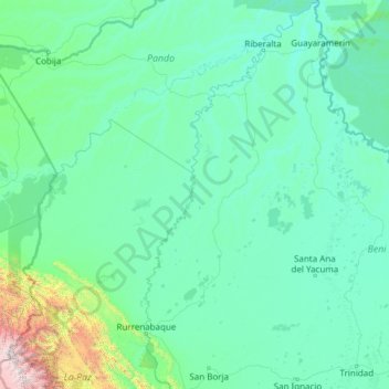
Nom : Carte topographique Beni River, altitude, relief.
Lieu : Beni River, Bolivia (-15.11488 -67.73812 -10.38055 -65.39099)
Altitude moyenne : 325 m
Altitude minimum : 108 m
Altitude maximum : 5 694 m
Faire un don
Équipez-vous pour votre prochaine aventure :
En tant que Partenaire Amazon, ce site perçoit une commission sur les achats éligibles sans surcoût pour vous.
Autres cartes topographiques
Cliquez sur une carte pour visualiser sa topographie, son altitude et son relief.
La Paz
Bolivia > La Paz > Pedro Domingo Murillo > La Paz
The city, in west-central Bolivia 68 km (42 mi) southeast of Lake Titicaca, is set in a canyon created by the Choqueyapu River. It is in a bowl-like depression, part of the Amazon basin, surrounded by the high mountains of the Altiplano. Overlooking the city is the towering, triple-peaked Illimani. Its peaks…
Altitude moyenne : 4 087 m
Sucre
Bolivia > Chuquisaca > Provincia Oropeza
Sucre (Spanish: [ˈsukɾe]) is the de jure capital city of Bolivia, the capital of the Chuquisaca Department and the sixth most populous city in Bolivia. Located in the south-central part of the country, Sucre lies at an elevation of 2,790 m (9,150 ft). This relatively high altitude gives the city a…
Altitude moyenne : 2 829 m
Santa Rosa de Kilo Kilo
Bolivia > La Paz > Provincia Nor Yungas > Municipio Coroico
Altitude moyenne : 1 321 m
Toro Toro
Bolivia > Potosí > Provincia Charcas > Municipio Toro Toro
Torotoro lies at an altitude of 2,676 m. It can only be reached by road from Estancia Sucusuma at the Río Caine. The town is at the centre of Torotoro National Park. It is 140 km south of Cochabamba.
Altitude moyenne : 2 792 m
Faire un don
Équipez-vous pour votre prochaine aventure :
En tant que Partenaire Amazon, ce site perçoit une commission sur les achats éligibles sans surcoût pour vous.
Huayna Potosí
Bolivia > La Paz > Provincia Los Andes > Pucarani
Huayna Potosí is a fold mountain located in western Bolivia, near the city of El Alto and approximately 25 km (16 mi) north of La Paz, the country's administrative capital. It rises to an elevation of 6,088 m (19,974 ft) above sea level and forms part of the Cordillera Real range of the larger Andes, which…
Altitude moyenne : 5 374 m
Faire un don
Équipez-vous pour votre prochaine aventure :
En tant que Partenaire Amazon, ce site perçoit une commission sur les achats éligibles sans surcoût pour vous.
Copacabana
Bolivia > La Paz > Provincia Manco Kapac
Copacabana has a dry-winter subpolar oceanic climate (Cwb), a rare variant of this type of climate, but commonplace near most of Lake Titicaca. Similar to many areas with this climate, Copacabana features a markedly drier "low-sun" season. Because of the high altitude of Copacabana, the town is chilly…
Altitude moyenne : 3 864 m
Mirador Arco de piedra
Bolivia > Potosí > Provincia Charcas > Municipio Toro Toro
Altitude moyenne : 3 547 m
Sucre
Bolivia > Chuquisaca > Provincia Oropeza
Sucre (Spanish pronunciation: [ˈsukɾe]; Quechua: Chuqichaka; Aymara: Sukri; Guarani: Sucre), officially La Ilustre y Heroica Sucre ("The Illustrious and Heroic Sucre") is the de jure capital city of Bolivia, the capital of the Chuquisaca Department and the sixth most populous city in Bolivia. Located in the…
Altitude moyenne : 2 829 m
Faire un don
Équipez-vous pour votre prochaine aventure :
En tant que Partenaire Amazon, ce site perçoit une commission sur les achats éligibles sans surcoût pour vous.
Sucre
Bolivia > Chuquisaca > Provincia Oropeza
Sucre (Spanish: [ˈsukɾe]) is the de jure capital city of Bolivia, the capital of the Chuquisaca Department and the sixth most populous city in Bolivia. Located in the south-central part of the country, Sucre lies at an elevation of 2,790 m (9,150 ft). This relatively high altitude gives the city a…
Altitude moyenne : 2 829 m
Illimani
Bolivia > La Paz > Pedro Domingo Murillo > Palca
Illimani (Aymara and Spanish pronunciation: [iʎiˈmani]) is a prominent fold mountain within the Cordillera Real of Bolivia, a subrange of the greater Andes, and located approximately 82 kilometres (51 mi) southeast of La Paz. With an elevation of 6,438 metres (21,120 ft) at its summit, it is the highest…
Altitude moyenne : 5 756 m
Faire un don
Équipez-vous pour votre prochaine aventure :
En tant que Partenaire Amazon, ce site perçoit une commission sur les achats éligibles sans surcoût pour vous.
Cachuela Esperanza
Bolivia > Beni > Guayaramerín
Cachuela Esperanza ("rapids of hope") is situated on the right bank at the rapids of Beni River, 30 km before its confluence with Mamoré River which both form the Madeira River there. The village is only accessible on dirt roads and is located at an elevation of 134 m.
Altitude moyenne : 121 m
Faire un don
Équipez-vous pour votre prochaine aventure :
En tant que Partenaire Amazon, ce site perçoit une commission sur les achats éligibles sans surcoût pour vous.
Faire un don
Équipez-vous pour votre prochaine aventure :
En tant que Partenaire Amazon, ce site perçoit une commission sur les achats éligibles sans surcoût pour vous.
Faire un don
Équipez-vous pour votre prochaine aventure :
En tant que Partenaire Amazon, ce site perçoit une commission sur les achats éligibles sans surcoût pour vous.
Jorochito
Bolivia > Santa Cruz > Provincia Andrés Ibáñez > Municipio El Torno
Altitude moyenne : 578 m
Oruro
Bolivia > Oruro > Provincia Cercado
Oruro lies north of the salty lakes Uru Uru and Poopó. It is three hours (by vehicle) from La Paz. Located at an altitude of 3709 meters above sea level, Oruro is well known for its cold weather. Warmer temperatures generally take place during August, September and October, after the worst of the winter…
Altitude moyenne : 3 751 m
Faire un don
Équipez-vous pour votre prochaine aventure :
En tant que Partenaire Amazon, ce site perçoit une commission sur les achats éligibles sans surcoût pour vous.
Samaipata
Bolivia > Santa Cruz > Provincia Florida > Municipio Samaipata
Samaipata or Samaypata (Quechua samay to rest, pata elevated place / above, at the top / edge, bank (of a river), shore) is a small town in the Florida Province of the Santa Cruz Department in Bolivia. It has a subtropical climate and an altitude of 1600–1800 m. It lies about 120 kilometers to the southwest…
Altitude moyenne : 1 695 m
Santiago de Huata
Bolivia > La Paz > Provincia Omasuyos > Municipio Santiago de Huata
Altitude moyenne : 3 911 m
Faire un don
Équipez-vous pour votre prochaine aventure :
En tant que Partenaire Amazon, ce site perçoit une commission sur les achats éligibles sans surcoût pour vous.
Faire un don
Équipez-vous pour votre prochaine aventure :
En tant que Partenaire Amazon, ce site perçoit une commission sur les achats éligibles sans surcoût pour vous.
Puerto Morales
Bolivia > Pando > Provincia de Abuná > Municipio Santa Rosa del Abuná
Altitude moyenne : 174 m
El Cuchi
Bolivia > Santa Cruz > Provincia Andrés Ibáñez > Municipio Porongo (Ayacucho)
Altitude moyenne : 379 m
Faire un don
Équipez-vous pour votre prochaine aventure :
En tant que Partenaire Amazon, ce site perçoit une commission sur les achats éligibles sans surcoût pour vous.
Faire un don
Équipez-vous pour votre prochaine aventure :
En tant que Partenaire Amazon, ce site perçoit une commission sur les achats éligibles sans surcoût pour vous.
Faire un don
Équipez-vous pour votre prochaine aventure :
En tant que Partenaire Amazon, ce site perçoit une commission sur les achats éligibles sans surcoût pour vous.
Morning Sun
Bolivia > Potosí > Provincia Sur Lípez > Municipio San Pablo de Lipez
Sol de Mañana is an area with geothermal manifestations in southern Bolivia, including fumaroles, hot springs and mud pools. It lies at about 4,900 metres (16,100 ft) elevation, south of Laguna Colorada and east of El Tatio geothermal field. The field is located within the Eduardo Avaroa Andean Fauna National…
Altitude moyenne : 4 894 m
Faire un don
Équipez-vous pour votre prochaine aventure :
En tant que Partenaire Amazon, ce site perçoit une commission sur les achats éligibles sans surcoût pour vous.
Nevado Sajama
Bolivia > Oruro > Sajama > Curahuara de Carangas
The mountain is covered by an ice cap, and Polylepis tarapacana trees occur up to 5,000 metres (16,000 ft) elevation.
Altitude moyenne : 5 771 m
Faire un don
Équipez-vous pour votre prochaine aventure :
En tant que Partenaire Amazon, ce site perçoit une commission sur les achats éligibles sans surcoût pour vous.
Faire un don
Équipez-vous pour votre prochaine aventure :
En tant que Partenaire Amazon, ce site perçoit une commission sur les achats éligibles sans surcoût pour vous.
Faire un don
Équipez-vous pour votre prochaine aventure :
En tant que Partenaire Amazon, ce site perçoit une commission sur les achats éligibles sans surcoût pour vous.
Santiago de Machaca
Bolivia > La Paz > Provincia General José Manuel Pando > Municipio Santiago de Machaca
Altitude moyenne : 3 873 m
Urubo
Bolivia > Santa Cruz > Provincia Andrés Ibáñez > Municipio Porongo (Ayacucho)
Altitude moyenne : 415 m
Faire un don
Équipez-vous pour votre prochaine aventure :
En tant que Partenaire Amazon, ce site perçoit une commission sur les achats éligibles sans surcoût pour vous.
Oruro
Bolivia > Oruro > Provincia Cercado
Oruro lies north of the salty lakes Uru Uru and Poopó. It is three hours (by vehicle) from La Paz. Located at an altitude of 3709 meters above sea level, Oruro is well known for its cold weather. Warmer temperatures generally take place during August, September and October, after the worst of the winter…
Altitude moyenne : 3 751 m
Faire un don
Équipez-vous pour votre prochaine aventure :
En tant que Partenaire Amazon, ce site perçoit une commission sur les achats éligibles sans surcoût pour vous.
Santa Maria
Bolivia > Santa Cruz > Provincia Guarayos > Ascencion de Guarayos
Altitude moyenne : 194 m
Santa Ana del Yacuma
Santa Ana is the capital of the Yacuma Province and the Santa Ana del Yacuma Municipality, located at an elevation of 144 m above sea level, where the Yacuma River meets the Mamoré River. Santa Ana is located 150 Kilometer north-west of Trinidad, the department's capital. The city has an Airport, the Santa…
Altitude moyenne : 142 m
Bella Vista
Bolivia > Beni > Iténez > Municipio Magdalena
Bella Vista is in the Magdalena Municipality of the Iténez Province at an elevation of 148 metres (486 ft). The town is 40 kilometres (25 mi) east of the provincial capital Magdalena and 240 kilometres (150 mi) northeast of Trinidad.
Altitude moyenne : 142 m
Faire un don
Équipez-vous pour votre prochaine aventure :
En tant que Partenaire Amazon, ce site perçoit une commission sur les achats éligibles sans surcoût pour vous.
Copacabana
Bolivia > La Paz > Provincia Manco Kapac
Copacabana features a cold subtropical highland climate (Köppen: Cwc, Trewartha: Cwlk) - a rare type of climate, but commonplace near most of Lake Titicaca. Similar to many areas with this climate, Copacabana features a markedly drier "low-sun" season. Because of the high altitude of Copacabana, the town is…
Altitude moyenne : 3 939 m
Faire un don
Équipez-vous pour votre prochaine aventure :
En tant que Partenaire Amazon, ce site perçoit une commission sur les achats éligibles sans surcoût pour vous.
Faire un don
Équipez-vous pour votre prochaine aventure :
En tant que Partenaire Amazon, ce site perçoit une commission sur les achats éligibles sans surcoût pour vous.
25 de Septiembre
Bolivia > La Paz > Provincia Sud Yungas > Municipio Palos Blancos
Altitude moyenne : 734 m
Faire un don
Équipez-vous pour votre prochaine aventure :
En tant que Partenaire Amazon, ce site perçoit une commission sur les achats éligibles sans surcoût pour vous.
Nueva Oscar
Bolivia > La Paz > Provincia Sud Yungas > Municipio Palos Blancos
Altitude moyenne : 518 m
Turux Napes
Bolivia > Santa Cruz > Provincia Ñuflo de Chávez > Municipio San Javier
Altitude moyenne : 402 m
Faire un don
Équipez-vous pour votre prochaine aventure :
En tant que Partenaire Amazon, ce site perçoit une commission sur les achats éligibles sans surcoût pour vous.
San Ramón
Bolivia > Santa Cruz > Provincia Ñuflo de Chávez > Municipio San Ramón
Altitude moyenne : 246 m
Caraguata
Bolivia > La Paz > Provincia Inquisivi > Municipio Licoma > Pencaloma
Altitude moyenne : 2 192 m
Faire un don
Équipez-vous pour votre prochaine aventure :
En tant que Partenaire Amazon, ce site perçoit une commission sur les achats éligibles sans surcoût pour vous.