
Carte topographique Rothhaus
Carte interactive
Cliquez sur la carte pour afficher l’altitude.
À propos de cette carte
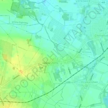
Nom : Carte topographique Rothhaus, altitude, relief.
Altitude moyenne : 162 m
Altitude minimum : 153 m
Altitude maximum : 176 m
Autres cartes topographiques
Cliquez sur une carte pour visualiser sa topographie, son altitude et son relief.
Chrosczütz
Polen > Woiwodschaft Oppeln > Landkreis Oppeln
Chrosczütz, Gemeinde Groß Döbern, Landkreis Oppeln, Woiwodschaft Oppeln, 46-080, Polen
Altitude moyenne : 149 m