
Carte topographique 85049
Carte interactive
Cliquez sur la carte pour afficher l’altitude.
À propos de cette carte
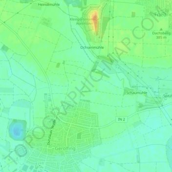
Nom : Carte topographique 85049, altitude, relief.
Lieu : 85049, West, Ingolstadt, Bayern, Deutschland (48.76375 11.35338 48.76385 11.35348)
Altitude moyenne : 377 m
Altitude minimum : 365 m
Altitude maximum : 397 m
Autres cartes topographiques
Cliquez sur une carte pour visualiser sa topographie, son altitude et son relief.
Dünzlau
Deutschland > Bayern > Ingolstadt > Dünzlauer Mühle
Dünzlau, Dünzlauer Mühle, West, Ingolstadt, Bayern, 85049, Deutschland
Altitude moyenne : 378 m
Niederfeld
Deutschland > Bayern > Ingolstadt
Niederfeld, Südost, Ingolstadt, Bayern, Deutschland
Altitude moyenne : 365 m
Unterbrunnenreuth
Deutschland > Bayern > Ingolstadt
Unterbrunnenreuth, Süd, Ingolstadt, Bayern, Deutschland
Altitude moyenne : 369 m
Irgertsheim
Deutschland > Bayern > Ingolstadt
Irgertsheim, West, Ingolstadt, Bayern, Deutschland
Altitude moyenne : 385 m
Zuchering
Deutschland > Bayern > Ingolstadt > Zuchering
Zuchering, Ingolstadt, Bayern, 85051, Deutschland
Altitude moyenne : 370 m
Gerolfing Nord
Deutschland > Bayern > Ingolstadt > Gerolfing Nord
Gerolfing Nord, West, Ingolstadt, Bayern, 85049, Deutschland
Altitude moyenne : 374 m
Richard-Strauss-Straße
Deutschland > Bayern > Ingolstadt
Richard-Strauss-Straße, Nordwest, Ingolstadt, Bayern, Deutschland
Altitude moyenne : 377 m