
Carte topographique Krosno
Carte interactive
Cliquez sur la carte pour afficher l’altitude.
À propos de cette carte
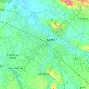
Nom : Carte topographique Krosno, altitude, relief.
Lieu : Krosno, Subcarpathian Voivodeship, Poland (49.64654 21.69469 49.73200 21.82795)
Altitude moyenne : 281 m
Altitude minimum : 253 m
Altitude maximum : 396 m
Krosno is on the river Wisłok. Slovakia is about 35 kilometres (22 mi) south, and Ukraine is about 85 kilometres (53 mi) east of the city. It is located in the heartland of the Doły (Pits), and its average altitude is 310 metres (1,020 ft) above sea level, although there are some hills located within the confines of the city.