
Carte topographique La Gandilhon
Carte interactive
Cliquez sur la carte pour afficher l’altitude.
À propos de cette carte
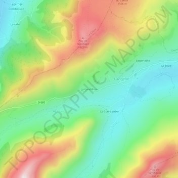
Nom : Carte topographique La Gandilhon, altitude, relief.
Altitude moyenne : 1 299 m
Altitude minimum : 1 038 m
Altitude maximum : 1 693 m
Autres cartes topographiques
Cliquez sur une carte pour visualiser sa topographie, son altitude et son relief.
La Gravière
France > Auvergne-Rhône-Alpes > Cantal > Lavigerie
La Gravière, Lavigerie, Saint-Flour, Cantal, Auvergne-Rhône-Alpes, France métropolitaine, 15300, France
Altitude moyenne : 1 290 m