
Carte topographique Walden
Carte interactive
Cliquez sur la carte pour afficher l’altitude.
Walden
Walden is the Statutory Town that is the county seat, the most populous community, and the only incorporated municipality in Jackson County, Colorado, United States. It is situated in the center of a large open valley called North Park. People from Walden and the surrounding area refer to themselves as "North Parkers". The town population was 606 at the 2020 census. The town sits at an elevation of 8,099 feet (2,469 meters). It was established in 1889 and was incorporated 2 December 1890. Mark A. Walden, an early postmaster, gave the community his name.
À propos de cette carte
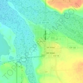
Nom : Carte topographique Walden, altitude, relief.
Lieu : Walden, Jackson County, Colorado, United States (40.72605 -106.28693 40.73695 -106.27409)
Altitude moyenne : 2 463 m
Altitude minimum : 2 447 m
Altitude maximum : 2 490 m
Autres cartes topographiques
Cliquez sur une carte pour visualiser sa topographie, son altitude et son relief.
Walden
United States > Colorado > Jackson County
Walden is the Statutory Town that is the county seat, the most populous community, and the only incorporated municipality in Jackson County, Colorado, United States. It is situated in the center of a large open valley called North Park. People from Walden and the surrounding area refer to themselves as "North…
Altitude moyenne : 2 463 m