
Carte topographique Ramat Negev Regional Council
Carte interactive
Cliquez sur la carte pour afficher l’altitude.
À propos de cette carte
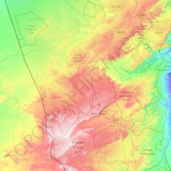
Nom : Carte topographique Ramat Negev Regional Council, altitude, relief.
Altitude moyenne : 415 m
Altitude minimum : -64 m
Altitude maximum : 1 022 m
Autres cartes topographiques
Cliquez sur une carte pour visualiser sa topographie, son altitude et son relief.
Sde Bokker
Israel > South District > Ramat Negev Regional Council
Sde Bokker, Ramat Negev Regional Council, Beersheba Subdistrict, South District, Israel
Altitude moyenne : 481 m
Sde Boker
Israel > South District > Ramat Negev Regional Council > Sde Boker
Sde Boker, Ramat Negev Regional Council, Beersheba Subdistrict, South District, 849000, Israel
Altitude moyenne : 486 m