
Carte topographique Curtaun
Carte interactive
Cliquez sur la carte pour afficher l’altitude.
À propos de cette carte
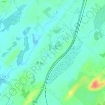
Nom : Carte topographique Curtaun, altitude, relief.
Altitude moyenne : 27 m
Altitude minimum : 16 m
Altitude maximum : 63 m
Autres cartes topographiques
Cliquez sur une carte pour visualiser sa topographie, son altitude et son relief.
Drought
Drought, Kilreekill ED, Loughrea Municipal District, County Galway, Connacht, Ireland
Altitude moyenne : 78 m
Costelloe
Costelloe, Conamara Municipal District, County Galway, Connacht, H91 A2T6, Ireland
Altitude moyenne : 12 m
Furbo
Furbo, County Galway, Connacht, H91 KX27, Ireland
Altitude moyenne : 16 m
Headford
Headford, Headford ED, Tuam Municipal District, County Galway, Connacht, Ireland
Altitude moyenne : 20 m
Gurteen
Gurteen, Cappalusk ED, Athenry-Oranmore Municipal District, County Galway, Connacht, Ireland
Altitude moyenne : 89 m
Glassilaun Beach
Glassilaun Beach, Cushkillary ED, Conamara Municipal District, County Galway, Connacht, Ireland
Altitude moyenne : 11 m
Eyrephort
Eyrephort, Clifden ED, Conamara Municipal District, County Galway, Connacht, Ireland
Altitude moyenne : 6 m
Mullaghmore East
Mullaghmore East, Cooloo ED, Ballinasloe Municipal District, County Galway, Connacht, Ireland
Altitude moyenne : 79 m
Loughrea Municipal District
Loughrea Municipal District, County Galway, Connacht, Ireland
Altitude moyenne : 69 m
Kilconnell
Kilconnell, Kilconnell ED, Ballinasloe Municipal District, County Galway, Connacht, Ireland
Altitude moyenne : 92 m
Cappataggle
Cappataggle, Killallaghtan ED, Ballinasloe Municipal District, County Galway, Connacht, Ireland
Altitude moyenne : 122 m
Tuam
Tuam, Tuam Municipal District, County Galway, Connacht, Ireland
Altitude moyenne : 40 m
Kiltullagh North
Kiltullagh North, Kiltullagh ED, Loughrea Municipal District, County Galway, Connacht, Ireland
Altitude moyenne : 46 m
Cappaghnagapple
Cappaghnagapple, Cloonbur ED, Conamara Municipal District, County Galway, Connacht, Ireland
Altitude moyenne : 72 m
Claregalway
Claregalway, Athenry-Oranmore Municipal District, County Galway, Connacht, H91 F5EH, Ireland
Altitude moyenne : 16 m
Derryclare
Derryclare, Conamara Municipal District, County Galway, Connacht, H91 TP63, Ireland
Altitude moyenne : 279 m
Ballinasloe Municipal District
Ballinasloe Municipal District, County Galway, Connacht, Ireland
Altitude moyenne : 66 m
Ballybrit
Ireland > County Galway > Galway
Ballybrit, Galway, County Galway, Connacht, Ireland
Altitude moyenne : 39 m
Carrowroe South
Carrowroe South, An Crompán, Conamara Municipal District, County Galway, Connacht, Ireland
Altitude moyenne : 11 m
Killeany
Killeany, Inishmore, Conamara Municipal District, County Galway, Connacht, H91 P266, Ireland
Altitude moyenne : 23 m
Gortnarup
Gortnarup, Cloonbur ED, Conamara Municipal District, County Galway, Connacht, Ireland
Altitude moyenne : 114 m
Athenry-Oranmore Municipal District
Athenry-Oranmore Municipal District, County Galway, Connacht, Ireland
Altitude moyenne : 42 m
Carrowroe
Carrowroe, Kilmeen ED, Loughrea Municipal District, County Galway, Connacht, Ireland
Altitude moyenne : 76 m
Fairhill
Fairhill, Mounthazel ED, Ballinasloe Municipal District, County Galway, Connacht, Ireland
Altitude moyenne : 87 m
Galway Bay
Galway Bay, County Galway, Connacht, Ireland
Altitude moyenne : 35 m
Newforest
Newforest, Curraghmore ED, Ballinasloe Municipal District, County Galway, Connacht, Ireland
Altitude moyenne : 82 m
Kylemore
Kylemore, Loughrea Municipal District, County Galway, Connacht, Ireland
Altitude moyenne : 45 m
Capira
Capira, Portumna ED, Loughrea Municipal District, County Galway, Connacht, Ireland
Altitude moyenne : 53 m