
Carte topographique Robertson County
Carte interactive
Cliquez sur la carte pour afficher l’altitude.
À propos de cette carte
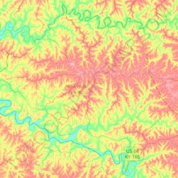
Nom : Carte topographique Robertson County, altitude, relief.
Lieu : Robertson County, Kentucky, 41064, USA (38.42021 -84.18392 38.60855 -83.93005)
Altitude moyenne : 239 m
Altitude minimum : 173 m
Altitude maximum : 305 m
Autres cartes topographiques
Cliquez sur une carte pour visualiser sa topographie, son altitude et son relief.
Tigers
USA > Kentucky > Louisville
Tigers, Louisville, Jefferson County, Kentucky, USA
Altitude moyenne : 155 m
Shelbyville
USA > Kentucky > Shelbyville
Shelbyville, Shelby County, Kentucky, 40065, USA
Altitude moyenne : 232 m
Georgetown
USA > Kentucky > Georgetown
Georgetown, Scott County, Kentucky, 40324, USA
Altitude moyenne : 265 m
Murray Hill
USA > Kentucky > Murray Hill
Murray Hill, Jefferson County, Kentucky, USA
Altitude moyenne : 194 m