
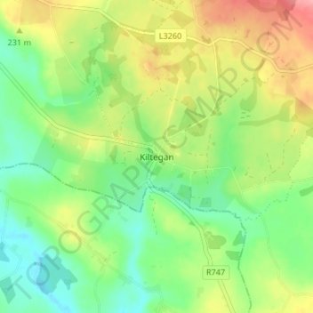
Carte topographique Kiltegan
Carte interactive
Cliquez sur la carte pour afficher l’altitude.
À propos de cette carte
Nom : Carte topographique Kiltegan, altitude, relief.
Altitude moyenne : 150 m
Altitude minimum : 110 m
Altitude maximum : 209 m
Autres cartes topographiques
Cliquez sur une carte pour visualiser sa topographie, son altitude et son relief.
Upper Lake
Upper Lake, Brockagh ED, The Municipal District of Wicklow, County Wicklow, Leinster, Ireland
Altitude moyenne : 331 m
The Municipal District of Baltinglass
The Municipal District of Baltinglass, County Wicklow, Leinster, Ireland
Altitude moyenne : 182 m
Calary
Calary, County Wicklow, Leinster, A98 KN50, Ireland
Altitude moyenne : 295 m
Enniskerry
Enniskerry, Enniskerry ED, The Municipal District of Bray, County Wicklow, Leinster, Ireland
Altitude moyenne : 104 m
The Municipal District of Bray
The Municipal District of Bray, County Wicklow, Leinster, Ireland
Altitude moyenne : 283 m
The Municipal District of Wicklow
The Municipal District of Wicklow, County Wicklow, Leinster, Ireland
Altitude moyenne : 263 m
Greystones
Ireland > County Wicklow > Greystones
Greystones, The Municipal District of Greystones, County Wicklow, Leinster, A63 HW80, Ireland
Altitude moyenne : 49 m
Arklow
Arklow, Arklow No 1 Urban ED, The Municipal District of Arklow, County Wicklow, Leinster, Ireland
Altitude moyenne : 14 m