
Carte topographique Lycabettus
Carte interactive
Cliquez sur la carte pour afficher l’altitude.
À propos de cette carte
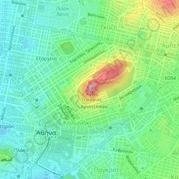
Nom : Carte topographique Lycabettus, altitude, relief.
Altitude moyenne : 125 m
Altitude minimum : 69 m
Altitude maximum : 262 m
Autres cartes topographiques
Cliquez sur une carte pour visualiser sa topographie, son altitude et son relief.
Dourgouti Region
Greece > Attica > Regional Unit of Central Athens > Athens
Dourgouti Region, Dourgouti, 2nd District of Athens, Athens, Municipality of Athens, Regional Unit of Central Athens, Attica, Greece
Altitude moyenne : 73 m
Philopappos Hill
Greece > Attica > Regional Unit of Central Athens > Athens
Philopappos Hill, Athens, Municipality of Athens, Regional Unit of Central Athens, Attica, 117 41, Greece
Altitude moyenne : 73 m
Άλσος Βεΐκου
Greece > Attica > Regional Unit of Central Athens > Athens
Άλσος Βεΐκου, Galatsi, Athens, Municipality of Galatsi, Regional Unit of Central Athens, Attica, Greece
Altitude moyenne : 171 m
Ιλισσός
Greece > Attica > Regional Unit of Central Athens > Athens
Ιλισσός, 7th District of Athens, Athens, Municipality of Athens, Regional Unit of Central Athens, Attica, 11527, Greece
Altitude moyenne : 140 m