
Carte topographique Phetchabun
Carte interactive
Cliquez sur la carte pour afficher l’altitude.
À propos de cette carte
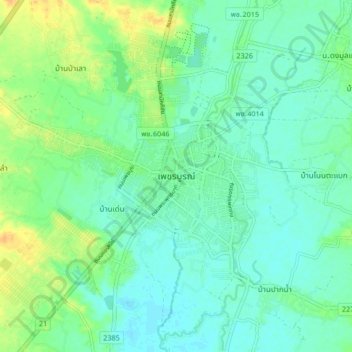
Nom : Carte topographique Phetchabun, altitude, relief.
Lieu : Phetchabun, Phetchabun Province, 67000, Thailand (16.37803 101.11568 16.45803 101.19568)
Altitude moyenne : 120 m
Altitude minimum : 110 m
Altitude maximum : 140 m
Autres cartes topographiques
Cliquez sur une carte pour visualiser sa topographie, son altitude et son relief.
Ban Nong Chaeng
Thailand > Phetchabun Province
Ban Nong Chaeng, Ban Phot, Phetchabun Province, Thailand
Altitude moyenne : 84 m
Wang Pong
Thailand > Phetchabun Province
Wang Pong, Phetchabun Province, Thailand
Altitude moyenne : 117 m