
Carte topographique Sigchos
Carte interactive
Cliquez sur la carte pour afficher l’altitude.
À propos de cette carte
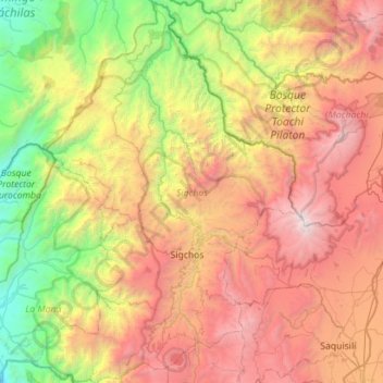
Nom : Carte topographique Sigchos, altitude, relief.
Lieu : Sigchos, Cotopaxi, Équateur (-0.89499 -79.11735 -0.33084 -78.72068)
Altitude moyenne : 2 432 m
Altitude minimum : 379 m
Altitude maximum : 5 174 m
Autres cartes topographiques
Cliquez sur une carte pour visualiser sa topographie, son altitude et son relief.
Tigua Rumichaca
Équateur > Cotopaxi > Pujilí > Zumbahua
Tigua Rumichaca, Zumbahua, Pujilí, Cotopaxi, 050405, Équateur
Altitude moyenne : 3 653 m
Itupungo Bajo
Équateur > Cotopaxi > Sigchos > Chugchillan
Itupungo Bajo, Chugchillan, Sigchos, Cotopaxi, 050504, Équateur
Altitude moyenne : 3 232 m
Quilotoa
Équateur > Cotopaxi > Sigchos > Chugchillan
Quilotoa, Chugchillan, Sigchos, Cotopaxi, 050456, Équateur
Altitude moyenne : 3 553 m
Volcán Cotopaxi
Équateur > Cotopaxi > Latacunga > Mulaló
Volcán Cotopaxi, Mulaló, Latacunga, Cotopaxi, Équateur
Altitude moyenne : 5 021 m
Laguna Quilotoa
Équateur > Cotopaxi > Zumbahua
Laguna Quilotoa, Avenida Zumbahua Quilotoa, Zumbahua, Pujilí, Cotopaxi, 050405, Équateur
Altitude moyenne : 3 632 m
San Fransisco
Équateur > Cotopaxi > Latacunga > Latacunga
San Fransisco, Eloy Alfaro, Latacunga, Cotopaxi, 050105, Équateur
Altitude moyenne : 2 887 m