
Carte topographique Teton Glacier
Carte interactive
Cliquez sur la carte pour afficher l’altitude.
À propos de cette carte
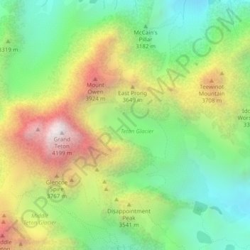
Nom : Carte topographique Teton Glacier, altitude, relief.
Altitude moyenne : 3 307 m
Altitude minimum : 2 719 m
Altitude maximum : 4 184 m
Autres cartes topographiques
Cliquez sur une carte pour visualiser sa topographie, son altitude et son relief.
Teepe Glacier
USA > Wyoming > Beaver Creek
Teepe Glacier, Garnet Canyon Trail, Beaver Creek, Teton County, Wyoming, USA
Altitude moyenne : 3 338 m
Middle Teton Glacier
USA > Wyoming > Beaver Creek
Middle Teton Glacier, Garnet Canyon Trail, Beaver Creek, Teton County, Wyoming, USA
Altitude moyenne : 3 383 m