
Faire un don
Équipez-vous pour votre prochaine aventure :
En tant que Partenaire Amazon, ce site perçoit une commission sur les achats éligibles sans surcoût pour vous.
Carte topographique Darstadt
Cliquez sur la carte pour afficher l’altitude.
Faire un don
Équipez-vous pour votre prochaine aventure :
En tant que Partenaire Amazon, ce site perçoit une commission sur les achats éligibles sans surcoût pour vous.
À propos de cette carte
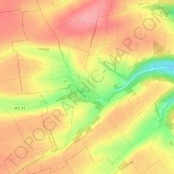
Nom : Carte topographique Darstadt, altitude, relief.
Lieu : Darstadt, Ochsenfurt, Landkreis Würzburg, Bayern, Deutschland (49.67197 9.99069 49.67725 10.00537)
Altitude moyenne : 278 m
Altitude minimum : 212 m
Altitude maximum : 315 m
Faire un don
Équipez-vous pour votre prochaine aventure :
En tant que Partenaire Amazon, ce site perçoit une commission sur les achats éligibles sans surcoût pour vous.
Autres cartes topographiques
Cliquez sur une carte pour visualiser sa topographie, son altitude et son relief.
Goßmannsdorf
Deutschland > Bayern > Landkreis Würzburg > Ochsenfurt
Vom 14. bis ins 19. Jahrhundert hatte der Ort eine geschlossene Dorfbefestigung, die aus einer Ringmauer mit drei großen und sieben kleinen Türmen bestand. Sie ist nur noch teilweise in ihrer alten Höhe erhalten.
Altitude moyenne : 246 m