
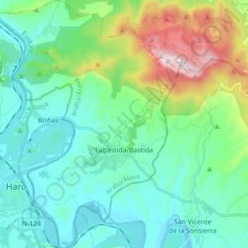
Carte topographique Labastida/Bastida
Carte interactive
Cliquez sur la carte pour afficher l’altitude.
À propos de cette carte
Nom : Carte topographique Labastida/Bastida, altitude, relief.
Altitude moyenne : 611 m
Altitude minimum : 423 m
Altitude maximum : 1 252 m
The town is at 529m altitude, and is positioned between the River Ebro and the Sierra de Toloño mountain range.
Autres cartes topographiques
Cliquez sur une carte pour visualiser sa topographie, son altitude et son relief.
Salinillas de Buradón/Gatzaga Buradon
Spain > Autonomous Community of the Basque Country > Arabako Errioxa/Rioja Alavesa > Labastida/Bastida
Salinillas de Buradón/Gatzaga Buradon, Labastida/Bastida, Arabako Errioxa/Rioja Alavesa, Álava, Autonomous Community of the Basque Country, Spain
Altitude moyenne : 599 m
Laguardia
Spain > Autonomous Community of the Basque Country > Arabako Errioxa/Rioja Alavesa
Laguardia, Arabako Errioxa/Rioja Alavesa, Álava, Autonomous Community of the Basque Country, Spain
Altitude moyenne : 592 m
Oyón/Oion
Spain > Autonomous Community of the Basque Country > Arabako Errioxa/Rioja Alavesa
Oyón/Oion, Arabako Errioxa/Rioja Alavesa, Álava, Autonomous Community of the Basque Country, 01320, Spain
Altitude moyenne : 572 m