
Carte topographique Gefrees
Carte interactive
Cliquez sur la carte pour afficher l’altitude.
À propos de cette carte
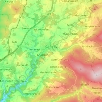
Nom : Carte topographique Gefrees, altitude, relief.
Lieu : Gefrees, Landkreis Bayreuth, Bavaria, 95482, Germany (50.04970 11.67457 50.13393 11.81840)
Altitude moyenne : 585 m
Altitude minimum : 385 m
Altitude maximum : 851 m
Autres cartes topographiques
Cliquez sur une carte pour visualiser sa topographie, son altitude et son relief.
Fichtelberg
Germany > Bavaria > Landkreis Bayreuth
Fichtelberg, Landkreis Bayreuth, Bavaria, 95686, Germany
Altitude moyenne : 697 m
Gottelhof
Germany > Bavaria > Landkreis Bayreuth > Hollfeld
Gottelhof, Hollfeld, Hollfeld (VGem), Landkreis Bayreuth, Bavaria, 95515, Germany
Altitude moyenne : 407 m
Röhrig
Germany > Bavaria > Landkreis Bayreuth > Bindlacher Berg
Röhrig, Bindlacher Berg, Bindlach, Landkreis Bayreuth, Bavaria, 95463, Germany
Altitude moyenne : 410 m
Plech
Germany > Bavaria > Landkreis Bayreuth
Plech, Betzenstein (VGem), Landkreis Bayreuth, Bavaria, 91287, Germany
Altitude moyenne : 475 m