
Carte topographique Herzogenbuchsee
Carte interactive
Cliquez sur la carte pour afficher l’altitude.
Herzogenbuchsee
Of the built up area, industrial buildings made up 3.1% of the total area while housing and buildings made up 14.2% and transportation infrastructure made up 7.5%. while parks, green belts and sports fields made up 1.5%. 34.0% of the total land area is heavily forested. Of the agricultural land, 30.9% is used for growing crops and 6.1% is pastures. All the water in the municipality is in rivers and streams. The elevation of the train station is 465 m (1,526 ft).
À propos de cette carte
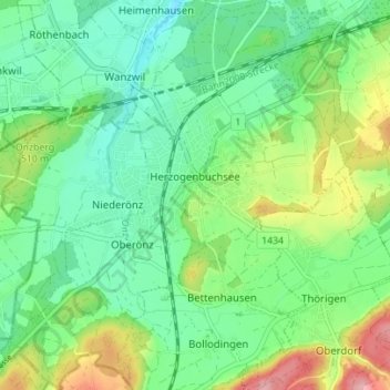
Nom : Carte topographique Herzogenbuchsee, altitude, relief.
Altitude moyenne : 485 m
Altitude minimum : 438 m
Altitude maximum : 589 m