
Faire un don
Équipez-vous pour votre prochaine aventure :
En tant que Partenaire Amazon, ce site perçoit une commission sur les achats éligibles sans surcoût pour vous.
Carte topographique Del Sur
Cliquez sur la carte pour afficher l’altitude.
Faire un don
Équipez-vous pour votre prochaine aventure :
En tant que Partenaire Amazon, ce site perçoit une commission sur les achats éligibles sans surcoût pour vous.
À propos de cette carte
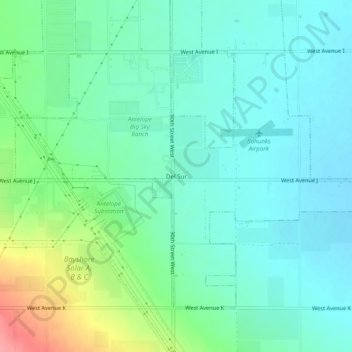
Nom : Carte topographique Del Sur, altitude, relief.
Lieu : Del Sur, Los Angeles County, California, United States (34.66971 -118.30869 34.70971 -118.26869)
Altitude moyenne : 746 m
Altitude minimum : 723 m
Altitude maximum : 813 m
Faire un don
Équipez-vous pour votre prochaine aventure :
En tant que Partenaire Amazon, ce site perçoit une commission sur les achats éligibles sans surcoût pour vous.
Autres cartes topographiques
Cliquez sur une carte pour visualiser sa topographie, son altitude et son relief.
Pacific Palisades
United States > California > Los Angeles County > Los Angeles
Pacific Palisades was formally founded in 1921 by a Methodist organization, and in the years that followed became a refuge for Jewish artists and intellectuals fleeing the Holocaust. The Palisades would later be sought after by celebrities and other high-profile individuals seeking privacy. It is known for its…
Altitude moyenne : 196 m
Santa Ynez Reservoir
United States > California > Los Angeles County > Los Angeles
Altitude moyenne : 307 m
Hollywood Hills
United States > California > Los Angeles County > Los Angeles
Altitude moyenne : 242 m
Faire un don
Équipez-vous pour votre prochaine aventure :
En tant que Partenaire Amazon, ce site perçoit une commission sur les achats éligibles sans surcoût pour vous.
Santa Susana Mountains
United States > California > Los Angeles County > Unincorporated Chatsworth
Altitude moyenne : 546 m
Arleta Neighborhood Council District
United States > California > Los Angeles County > Los Angeles
Altitude moyenne : 274 m
Faire un don
Équipez-vous pour votre prochaine aventure :
En tant que Partenaire Amazon, ce site perçoit une commission sur les achats éligibles sans surcoût pour vous.
Los Angeles City Council District 5
United States > California > Los Angeles County > Los Angeles
Altitude moyenne : 131 m
West Hills Neighborhood Council District
United States > California > Los Angeles County > Los Angeles
Altitude moyenne : 319 m
Faire un don
Équipez-vous pour votre prochaine aventure :
En tant que Partenaire Amazon, ce site perçoit une commission sur les achats éligibles sans surcoût pour vous.
Angeles National Forest
United States > California > Los Angeles County
The Angeles National Forest manages the habitats, flora and fauna ecosystems, and watersheds. Some of the rivers with watersheds within its boundaries provide valuable non-groundwater recharge water for Southern California. The existing protected and restored native vegetation absorb and slow surface runoff of…
Altitude moyenne : 782 m
Los Angeles City Council District 7
United States > California > Los Angeles County > Los Angeles
Altitude moyenne : 512 m
Los Angeles City Council District 6
United States > California > Los Angeles County > Los Angeles
Altitude moyenne : 252 m
Faire un don
Équipez-vous pour votre prochaine aventure :
En tant que Partenaire Amazon, ce site perçoit une commission sur les achats éligibles sans surcoût pour vous.
Faire un don
Équipez-vous pour votre prochaine aventure :
En tant que Partenaire Amazon, ce site perçoit une commission sur les achats éligibles sans surcoût pour vous.
Faire un don
Équipez-vous pour votre prochaine aventure :
En tant que Partenaire Amazon, ce site perçoit une commission sur les achats éligibles sans surcoût pour vous.
Avocado Heights
United States > California > Los Angeles County > Avocado Heights
Altitude moyenne : 112 m
Faire un don
Équipez-vous pour votre prochaine aventure :
En tant que Partenaire Amazon, ce site perçoit une commission sur les achats éligibles sans surcoût pour vous.
Faire un don
Équipez-vous pour votre prochaine aventure :
En tant que Partenaire Amazon, ce site perçoit une commission sur les achats éligibles sans surcoût pour vous.
San Gabriel River
United States > California > Los Angeles County > Pico Rivera
Altitude moyenne : 89 m
Faire un don
Équipez-vous pour votre prochaine aventure :
En tant que Partenaire Amazon, ce site perçoit une commission sur les achats éligibles sans surcoût pour vous.
Mount Wilson Observatory
United States > California > Los Angeles County > Mount Wilson
Altitude moyenne : 1 421 m
Faire un don
Équipez-vous pour votre prochaine aventure :
En tant que Partenaire Amazon, ce site perçoit une commission sur les achats éligibles sans surcoût pour vous.
Los Angeles River
United States > California > Los Angeles County > Los Angeles
Altitude moyenne : 243 m
Faire un don
Équipez-vous pour votre prochaine aventure :
En tant que Partenaire Amazon, ce site perçoit une commission sur les achats éligibles sans surcoût pour vous.
Val Verde
United States > California > Los Angeles County
Val Verde is located in the San Martinez Chiquito Canyon in the southeastern foothills of the Topatopa Mountains at an elevation ranging from 1,250–1,400 feet (380–430 m). The canyon contains a creek with runs intermittently through the community. It is about 50 miles (80 km) northwest of the county seat…
Altitude moyenne : 440 m
Runyon Canyon Park
United States > California > Los Angeles County > Los Angeles
Altitude moyenne : 235 m
Faire un don
Équipez-vous pour votre prochaine aventure :
En tant que Partenaire Amazon, ce site perçoit une commission sur les achats éligibles sans surcoût pour vous.
East Rancho Dominguez County Park
United States > California > Los Angeles County > East Compton
Altitude moyenne : 22 m
Faire un don
Équipez-vous pour votre prochaine aventure :
En tant que Partenaire Amazon, ce site perçoit une commission sur les achats éligibles sans surcoût pour vous.
Faire un don
Équipez-vous pour votre prochaine aventure :
En tant que Partenaire Amazon, ce site perçoit une commission sur les achats éligibles sans surcoût pour vous.
Golden Shore Marine Biological Reserve
United States > California > Los Angeles County > Long Beach
Altitude moyenne : 7 m
Lake Elizabeth
United States > California > Los Angeles County
The lake, at 984 m (3,228 ft) in elevation, is within the Angeles National Forest. It is a natural perennial lake, but may dry up entirely during drought years. It is south of the western Antelope Valley.
Altitude moyenne : 1 065 m
Faire un don
Équipez-vous pour votre prochaine aventure :
En tant que Partenaire Amazon, ce site perçoit une commission sur les achats éligibles sans surcoût pour vous.
Topanga State Park
United States > California > Los Angeles County > Los Angeles
Altitude moyenne : 333 m
Faire un don
Équipez-vous pour votre prochaine aventure :
En tant que Partenaire Amazon, ce site perçoit une commission sur les achats éligibles sans surcoût pour vous.
Edward Vincent Jr. Park
United States > California > Los Angeles County > Inglewood
Altitude moyenne : 56 m
Augustus F. Hawkins Natural Park
United States > California > Los Angeles County > Los Angeles
Altitude moyenne : 55 m
Faire un don
Équipez-vous pour votre prochaine aventure :
En tant que Partenaire Amazon, ce site perçoit une commission sur les achats éligibles sans surcoût pour vous.
La Puerta Sports Park
United States > California > Los Angeles County > Claremont
Altitude moyenne : 471 m
Whittier Narrows
United States > California > Los Angeles County > South El Monte
Altitude moyenne : 75 m
Stoneview Nature Center
United States > California > Los Angeles County > Culver City
Altitude moyenne : 64 m
Faire un don
Équipez-vous pour votre prochaine aventure :
En tant que Partenaire Amazon, ce site perçoit une commission sur les achats éligibles sans surcoût pour vous.
Genesee Avenue Park
United States > California > Los Angeles County > Los Angeles
Altitude moyenne : 33 m