
Carte topographique Findhorn
Carte interactive
Cliquez sur la carte pour afficher l’altitude.
À propos de cette carte
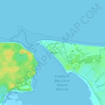
Nom : Carte topographique Findhorn, altitude, relief.
Lieu : Findhorn, Moray, Schotland, IV36 3YG, Verenigd Koninkrijk (57.63911 -3.63070 57.67911 -3.59070)
Altitude moyenne : 3 m
Altitude minimum : -1 m
Altitude maximum : 24 m
Autres cartes topographiques
Cliquez sur une carte pour visualiser sa topographie, son altitude et son relief.
Mayern
Verenigd Koninkrijk > Schotland > Moray
Mayern, Moray, Schotland, AB54 7NL, Verenigd Koninkrijk
Altitude moyenne : 143 m
Tomintoul
Verenigd Koninkrijk > Schotland > Moray
Tomintoul, Moray, Schotland, AB37 9ET, Verenigd Koninkrijk
Altitude moyenne : 374 m
Pluscarden
Verenigd Koninkrijk > Schotland > Moray
Pluscarden, Moray, Schotland, IV30 8UB, Verenigd Koninkrijk
Altitude moyenne : 130 m
Elgin
Verenigd Koninkrijk > Schotland > Moray
Elgin, Moray, Schotland, IV30 1EB, Verenigd Koninkrijk
Altitude moyenne : 26 m