
Carte topographique Lousã
Carte interactive
Cliquez sur la carte pour afficher l’altitude.
À propos de cette carte
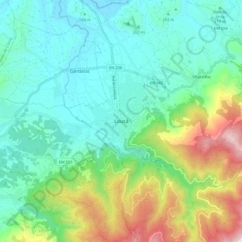
Nom : Carte topographique Lousã, altitude, relief.
Lieu : Lousã, Lousã e Vilarinho, Lousã, Coimbra, 3200-200, Portugal (40.07115 -8.28616 40.15115 -8.20616)
Altitude moyenne : 335 m
Altitude minimum : 75 m
Altitude maximum : 1 048 m
Lousã sits at around 200 m (660 ft) high, and it currently has an active station at its aerodrome, but because this station is relatively new, data from the older, now inactive station in the mountains nearby, at a higher altitude, is also represented in the climate chart below: