
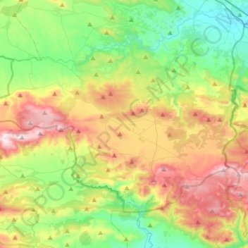
Carte topographique Δημοτική Ενότητα Δερβενοχωρίων
Carte interactive
Cliquez sur la carte pour afficher l’altitude.
À propos de cette carte
Nom : Carte topographique Δημοτική Ενότητα Δερβενοχωρίων, altitude, relief.
Altitude moyenne : 417 m
Altitude minimum : 62 m
Altitude maximum : 1 011 m
Autres cartes topographiques
Cliquez sur une carte pour visualiser sa topographie, son altitude et son relief.
Levadia Municipal Unit
Greece > Thessaly and Central Greece > Regional Unit of Boeotia
Levadia Municipal Unit, Municipality of Livadia, Regional Unit of Boeotia, Central Greece, Thessaly and Central Greece, Greece
Altitude moyenne : 468 m
Livadia
Greece > Thessaly and Central Greece > Regional Unit of Boeotia > Levadia Municipal Unit
Livadia, Levadia Municipal Unit, Municipality of Livadia, Regional Unit of Boeotia, Central Greece, Thessaly and Central Greece, 321 00, Greece
Altitude moyenne : 313 m
Pyli
Greece > Thessaly and Central Greece > Regional Unit of Boeotia > Δημοτική Ενότητα Δερβενοχωρίων
Pyli, Δημοτική Ενότητα Δερβενοχωρίων, Municipality of Tanagra, Regional Unit of Boeotia, Central Greece, Thessaly and Central Greece, 190 12, Greece
Altitude moyenne : 574 m
Cheronia
Greece > Thessaly and Central Greece > Regional Unit of Boeotia > Cheronia
Cheronia, Χαιρώνεια - Ακόντιο, Κοινότητα Χαιρώνειας, Cheronia, Municipality of Livadia, Regional Unit of Boeotia, Central Greece, Thessaly and Central Greece, 321 00, Greece
Altitude moyenne : 147 m
Arachova
Greece > Thessaly and Central Greece > Regional Unit of Boeotia > Δημοτική Ενότητα Αραχώβης > Arachova
Arachova, Δημοτική Ενότητα Αραχώβης, Distomo-Arachova-Antikyra Municipality, Regional Unit of Boeotia, Central Greece, Thessaly and Central Greece, 32004, Greece
Altitude moyenne : 901 m
Tanagra
Greece > Thessaly and Central Greece > Regional Unit of Boeotia > Δημοτική Ενότητα Τανάγρας > Tanagra
Tanagra, Δημοτική Ενότητα Τανάγρας, Municipality of Tanagra, Regional Unit of Boeotia, Central Greece, Thessaly and Central Greece, 32009, Greece
Altitude moyenne : 231 m