
Faire un don
Équipez-vous pour votre prochaine aventure :
En tant que Partenaire Amazon, ce site perçoit une commission sur les achats éligibles sans surcoût pour vous.
Carte topographique Muğla
Cliquez sur la carte pour afficher l’altitude.
Faire un don
Équipez-vous pour votre prochaine aventure :
En tant que Partenaire Amazon, ce site perçoit une commission sur les achats éligibles sans surcoût pour vous.
Muğla
Muğla (Turkish: [ˈmuːɫa]) is a city in southwestern Turkey. The city is the center of the district of Menteşe and Muğla Province, which stretches along Turkey's Aegean coast. Muğla's center is situated inland at an altitude of 660 m and lies at a distance of about 30 km (19 mi) from the nearest seacoast in the Gulf of Gökova to its south-west. Muğla (Menteşe) district area neighbors the district areas of Milas, Yatağan and Kavaklıdere to its north by north-west and those of Ula and Köyceğiz, all of whom are dependent districts. Muğla is the administrative capital of a province that incorporates internationally well-known and popular tourist resorts such as Bodrum, Marmaris, Datça, Dalyan, Fethiye, Ölüdeniz and also the smaller resort of Sarigerme.
Faire un don
Équipez-vous pour votre prochaine aventure :
En tant que Partenaire Amazon, ce site perçoit une commission sur les achats éligibles sans surcoût pour vous.
À propos de cette carte
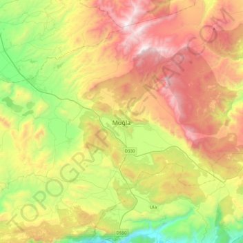
Nom : Carte topographique Muğla, altitude, relief.
Lieu : Muğla, Menteşe, Muğla, Aegean Region, 48050, Turkey (37.05518 28.20373 37.37518 28.52373)
Altitude moyenne : 841 m
Altitude minimum : 23 m
Altitude maximum : 1 882 m
Faire un don
Équipez-vous pour votre prochaine aventure :
En tant que Partenaire Amazon, ce site perçoit une commission sur les achats éligibles sans surcoût pour vous.