
Carte topographique Shaniko
Carte interactive
Cliquez sur la carte pour afficher l’altitude.
Shaniko
The city is at an elevation of 3,343 feet (1,019 m). On the high plateau on which Shaniko was built, the soil is thin and the vegetation sparse, consisting mainly of sagebrush, bunchgrass, and occasional junipers. Many peaks of the Cascade Range, including Hood, Jefferson, Adams, St. Helens and Rainier, are visible from the city.
À propos de cette carte
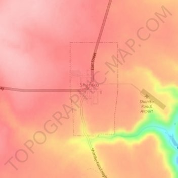
Nom : Carte topographique Shaniko, altitude, relief.
Lieu : Shaniko, Wasco County, Oregon, United States (44.99660 -120.75733 45.01082 -120.74709)
Altitude moyenne : 1 009 m
Altitude minimum : 900 m
Altitude maximum : 1 038 m