
Carte topographique Coche Island
Carte interactive
Cliquez sur la carte pour afficher l’altitude.
Coche Island
It covers an area of 55 km2 (21 sq mi) (11 km (7 mi) long by 6 km (4 mi)), with a population of about 8,200 (1999 census). The highest elevation of the island is 60 metres (197 ft) above sea level. The climate is tropical, with an average temperature of approximately 27 to 38 °C (81 to 100 °F).
À propos de cette carte
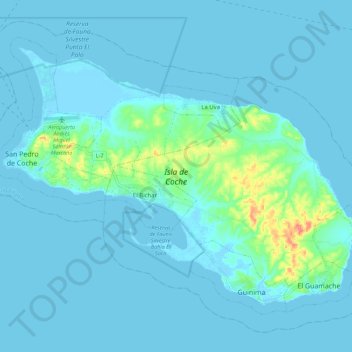
Nom : Carte topographique Coche Island, altitude, relief.
Altitude moyenne : 6 m
Altitude minimum : -2 m
Altitude maximum : 61 m