
Carte topographique Wachau Cultural Landscape
Carte interactive
Cliquez sur la carte pour afficher l’altitude.
À propos de cette carte
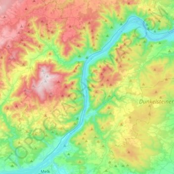
Nom : Carte topographique Wachau Cultural Landscape, altitude, relief.
Altitude moyenne : 486 m
Altitude minimum : 189 m
Altitude maximum : 961 m
The Danube valley in Austria between the cities of Melk and Krems in Lower Austria is called the Wachau. This stretch of the valley includes the hills and the adjacent Dunkelsteiner Wald (Dunkelsteiner Forest) and the southern Waldviertel. The Danube river flows north-northeast from Melk to Dürnstein through a meander from which it flows southeast, then east past the city of Krems. In the Wachau, the town of Spitz lies on the Danube's western bank and the city of Melk on its eastern bank. Other important towns in the valley are Dürnstein, Weißenkirchen in der Wachau and Emmersdorf an der Donau, which have a galaxy of old homestead buildings dating from the mid-6th century. The railway line built in 1909 between Krems and Emmersdorf is a topographical marvel. Other settlements of note in the Wachau valley include Aggsbach, Bachamsdorf, Bergern im Dunkelsteinerwald, Furth bei Göttweig, Joching, Maria Laach am Jauerling, Mautern an der Donau, Mühldorf, Oberamsdorf, Oberloiben, Rossatz-Arnsdorf, Ruhrsdorf, Schwallenbach, Schönbühel-Aggsbach, Unterloiben and Willendorf.
Autres cartes topographiques
Cliquez sur une carte pour visualiser sa topographie, son altitude et son relief.
Schenkenbrunn
Austria > Lower Austria > Bezirk Krems > Bergern im Dunkelsteinerwald
Schenkenbrunn, Bergern im Dunkelsteinerwald, Bezirk Krems, Lower Austria, 3122, Austria
Altitude moyenne : 511 m