
Carte topographique Town of Gainesville
Carte interactive
Cliquez sur la carte pour afficher l’altitude.
À propos de cette carte
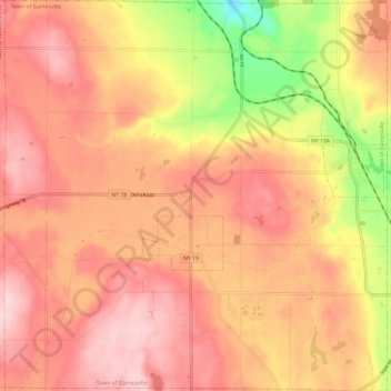
Nom : Carte topographique Town of Gainesville, altitude, relief.
Lieu : Town of Gainesville, Wyoming County, New York, United States (42.60819 -78.19125 42.69603 -78.07407)
Altitude moyenne : 490 m
Altitude minimum : 350 m
Altitude maximum : 563 m
Autres cartes topographiques
Cliquez sur une carte pour visualiser sa topographie, son altitude et son relief.
Village of Arcade
United States > New York > Wyoming County
Village of Arcade, Town of Arcade, Wyoming County, New York, United States
Altitude moyenne : 478 m
Village of Silver Springs
United States > New York > Wyoming County > Town of Gainesville
Village of Silver Springs, Town of Gainesville, Wyoming County, New York, United States
Altitude moyenne : 447 m
Town of Bennington
United States > New York > Wyoming County
Town of Bennington, Wyoming County, New York, 14037, United States
Altitude moyenne : 383 m