
Carte topographique Jeker
Carte interactive
Cliquez sur la carte pour afficher l’altitude.
À propos de cette carte
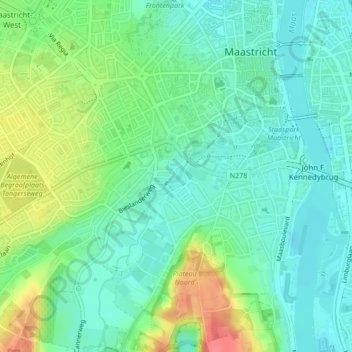
Nom : Carte topographique Jeker, altitude, relief.
Altitude moyenne : 64 m
Altitude minimum : 43 m
Altitude maximum : 110 m
Autres cartes topographiques
Cliquez sur une carte pour visualiser sa topographie, son altitude et son relief.
Sint-Pietersberg
Nederland > Limburg > Maastricht
Sint-Pietersberg, Maastricht, Limburg, Nederland, 6212NJ, Nederland
Altitude moyenne : 71 m
D'n Observant
Nederland > Limburg > Maastricht
D'n Observant, Maastricht, Limburg, Nederland, 6212NA, Nederland
Altitude moyenne : 64 m
Maastricht
Nederland > Limburg > Maastricht
Maastricht, Limburg, Nederland, 6211CS, Nederland
Altitude moyenne : 101 m
Sint-Pietersberg
Nederland > Limburg > Maastricht
Sint-Pietersberg, Maastricht, Limburg, Nederland, 6212 NE, Nederland
Altitude moyenne : 62 m
Borgharen
Nederland > Limburg > Maastricht
Borgharen, Maastricht, Limburg, Nederland, 6223 BL, Nederland
Altitude moyenne : 51 m
Chateau Neercanne
Nederland > Limburg > Maastricht
Chateau Neercanne, Cannerweg, Maastricht, Limburg, Nederland, 6213ND, Nederland
Altitude moyenne : 85 m