
Carte topographique Malinau
Carte interactive
Cliquez sur la carte pour afficher l’altitude.
À propos de cette carte
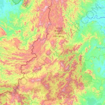
Nom : Carte topographique Malinau, altitude, relief.
Lieu : Malinau, North Kalimantan, 77554, Indonesia (1.11404 114.56516 4.12322 116.79401)
Altitude moyenne : 627 m
Altitude minimum : -3 m
Altitude maximum : 2 298 m
Malinau borders Nunukan Regency in the north, Tana Tidung, Bulungan, and Berau regencies in the east, East Kutai, Kutai Kartanegara, and West Kutai regencies in the south, and the Malaysian state of Sabah in the west. From its 40,088.38 square kilometers of area, Kayan Mentarang National Park consist of 24.88% of total regency's area. Other than that, other 16.97% of the regency is protected forest, and 49.69% is production forest. Topography in Malinau varies between altitude of 0 to 2,000 metres above sea level with slope between 0% to 40%. Human settlement and ricefields are mostly found between region with slope of 3% to 15%. The regency is considered located on relatively high altitude compared to its neighbouring regions.
Autres cartes topographiques
Cliquez sur une carte pour visualiser sa topographie, son altitude et son relief.
Long Bang
Indonesia > North Kalimantan > Bulungan
Long Bang, Bulungan, North Kalimantan, Indonesia
Altitude moyenne : 56 m
Tarakan Island
Indonesia > North Kalimantan > Tarakan
Tarakan Island, Tarakan, North Kalimantan, 77112, Indonesia
Altitude moyenne : 11 m