
Carte topographique Heisterbacherrott
Carte interactive
Cliquez sur la carte pour afficher l’altitude.
À propos de cette carte
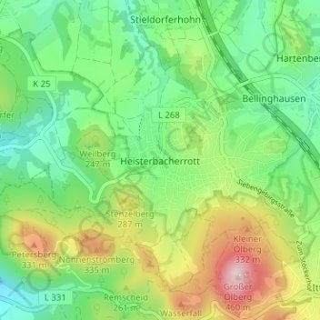
Nom : Carte topographique Heisterbacherrott, altitude, relief.
Altitude moyenne : 211 m
Altitude minimum : 91 m
Altitude maximum : 436 m
Autres cartes topographiques
Cliquez sur une carte pour visualiser sa topographie, son altitude et son relief.
Uthweiler
Germany > North Rhine-Westphalia > Rhein-Sieg-Kreis > Königswinter > Uthweiler
Uthweiler, Königswinter, Rhein-Sieg-Kreis, North Rhine-Westphalia, 53639, Germany
Altitude moyenne : 157 m