
Carte topographique Ogden Dunes
Carte interactive
Cliquez sur la carte pour afficher l’altitude.
À propos de cette carte
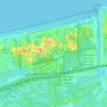
Nom : Carte topographique Ogden Dunes, altitude, relief.
Lieu : Ogden Dunes, Porter County, Indiana, United States (41.61433 -87.20288 41.63037 -87.18352)
Altitude moyenne : 184 m
Altitude minimum : 175 m
Altitude maximum : 210 m
Autres cartes topographiques
Cliquez sur une carte pour visualiser sa topographie, son altitude et son relief.
Morgan Park
United States > Indiana > Porter County > Chesterton
Morgan Park, Chesterton, Porter County, Indiana, 46304, United States
Altitude moyenne : 197 m
Chesterton
United States > Indiana > Porter County
Chesterton, Porter County, Indiana, 46304, United States
Altitude moyenne : 200 m
Beverly Shores
United States > Indiana > Porter County > Beverly Shores > Beverly Shores
Beverly Shores, Porter County, Indiana, 46301, United States
Altitude moyenne : 182 m
Beverly Shores
United States > Indiana > Porter County
Beverly Shores, Porter County, Indiana, 46301, United States
Altitude moyenne : 186 m
Valparaiso
United States > Indiana > Porter County
Valparaiso, Porter County, Indiana, 46383, United States
Altitude moyenne : 235 m
Portage
United States > Indiana > Porter County
Portage, Porter County, Indiana, United States
Altitude moyenne : 190 m