
Carte topographique Great Sand Dunes National Park
Carte interactive
Cliquez sur la carte pour afficher l’altitude.
À propos de cette carte
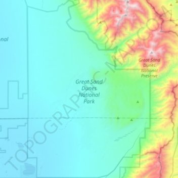
Nom : Carte topographique Great Sand Dunes National Park, altitude, relief.
Altitude moyenne : 2 616 m
Altitude minimum : 2 292 m
Altitude maximum : 4 100 m
In 1848, John C. Frémont was hired to find a railroad route from St. Louis to California. He crossed the Sangre de Cristos into the San Luis Valley in winter, courting disaster but proving that a winter crossing of this range was possible. He was followed in 1853 by Captain John Gunnison of the Corps of Topographical Engineers. Gunnison's party crossed the dunefield on horseback.[11]
Autres cartes topographiques
Cliquez sur une carte pour visualiser sa topographie, son altitude et son relief.
La Garita
United States > Colorado > Saguache County
La Garita, Saguache County, Colorado, United States
Altitude moyenne : 2 384 m
Twin Mountains
United States > Colorado > Saguache County
Twin Mountains, Saguache County, Colorado, United States
Altitude moyenne : 2 919 m
Challenger Point
United States > Colorado > Saguache County
Challenger Point, Saguache County, Colorado, United States
Altitude moyenne : 3 781 m
Crestone
United States > Colorado > Saguache County
Crestone, Saguache County, Colorado, United States
Altitude moyenne : 2 444 m
Great Sand Dunes National Preserve
United States > Colorado > Saguache County
Great Sand Dunes National Preserve, Saguache County, Colorado, United States
Altitude moyenne : 2 792 m